

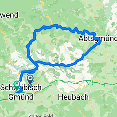
Spraitbach - Durlangen
A cycling route starting in Mutlangen, Baden-Wurttemberg, Germany.
Overview
About this route
12.04.15 15:41
- -:--
- Duration
- 31.5 km
- Distance
- 269 m
- Ascent
- 270 m
- Descent
- ---
- Avg. speed
- ---
- Max. altitude
Route quality
Waytypes & surfaces along the route
Waytypes
Track
12.3 km
(39 %)
Road
8.2 km
(26 %)
Surfaces
Paved
16.1 km
(51 %)
Unpaved
4.1 km
(13 %)
Asphalt
7.9 km
(25 %)
Paved (undefined)
6.3 km
(20 %)
Continue with Bikemap
Use, edit, or download this cycling route
You would like to ride Spraitbach - Durlangen or customize it for your own trip? Here is what you can do with this Bikemap route:
Free features
- Save this route as favorite or in collections
- Copy & plan your own version of this route
- Sync your route with Garmin or Wahoo
Premium features
Free trial for 3 days, or one-time payment. More about Bikemap Premium.
- Navigate this route on iOS & Android
- Export a GPX / KML file of this route
- Create your custom printout (try it for free)
- Download this route for offline navigation
Discover more Premium features.
Get Bikemap PremiumFrom our community
Other popular routes starting in Mutlangen
 Rehnenmühle
- Distance
- 17.1 km
- Ascent
- 173 m
- Descent
- 174 m
- Location
- Mutlangen, Baden-Wurttemberg, Germany
 Spraitbach - Durlangen
- Distance
- 31.5 km
- Ascent
- 269 m
- Descent
- 270 m
- Location
- Mutlangen, Baden-Wurttemberg, Germany
 Mutlangen - Ebnisee
- Distance
- 60.4 km
- Ascent
- 757 m
- Descent
- 723 m
- Location
- Mutlangen, Baden-Wurttemberg, Germany
 leital kochertal
- Distance
- 58.3 km
- Ascent
- 697 m
- Descent
- 638 m
- Location
- Mutlangen, Baden-Wurttemberg, Germany
 Wetzgau 7km
- Distance
- 6.8 km
- Ascent
- 150 m
- Descent
- 155 m
- Location
- Mutlangen, Baden-Wurttemberg, Germany
 Deinbach Rechber
- Distance
- 27 km
- Ascent
- 480 m
- Descent
- 518 m
- Location
- Mutlangen, Baden-Wurttemberg, Germany
 2009 01
- Distance
- 40.6 km
- Ascent
- 387 m
- Descent
- 484 m
- Location
- Mutlangen, Baden-Wurttemberg, Germany
 Radrunde Kloster.schelmenklinge. Alfdorf
- Distance
- 15.8 km
- Ascent
- 271 m
- Descent
- 306 m
- Location
- Mutlangen, Baden-Wurttemberg, Germany
Open it in the app