

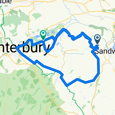
20150323_082519.gpx
A cycling route starting in Ash, England, United Kingdom.
Overview
About this route
TEASI track
- -:--
- Duration
- 32.4 km
- Distance
- 117 m
- Ascent
- 116 m
- Descent
- ---
- Avg. speed
- ---
- Max. altitude
Route quality
Waytypes & surfaces along the route
Waytypes
Road
17.8 km
(55 %)
Quiet road
9.4 km
(29 %)
Surfaces
Paved
25.9 km
(80 %)
Asphalt
25.9 km
(80 %)
Undefined
6.5 km
(20 %)
Route highlights
Points of interest along the route
Point of interest after 0 km
LITTLE IMPETTS
Point of interest after 0 km
LITTLE IMPETTS
Point of interest after 14.8 km
CANTERBURY CITY
Point of interest after 23.9 km
THE RED LION
Point of interest after 28.1 km
THE LITTLE GROVE INN
Continue with Bikemap
Use, edit, or download this cycling route
You would like to ride 20150323_082519.gpx or customize it for your own trip? Here is what you can do with this Bikemap route:
Free features
- Save this route as favorite or in collections
- Copy & plan your own version of this route
- Sync your route with Garmin or Wahoo
Premium features
Free trial for 3 days, or one-time payment. More about Bikemap Premium.
- Navigate this route on iOS & Android
- Export a GPX / KML file of this route
- Create your custom printout (try it for free)
- Download this route for offline navigation
Discover more Premium features.
Get Bikemap PremiumFrom our community
Other popular routes starting in Ash
 PluckGutter2Canterbury
- Distance
- 18.8 km
- Ascent
- 70 m
- Descent
- 59 m
- Location
- Ash, England, United Kingdom
 Tuesday
- Distance
- 24.7 km
- Ascent
- 220 m
- Descent
- 216 m
- Location
- Ash, England, United Kingdom
 Challnge 75
- Distance
- 118.8 km
- Ascent
- 523 m
- Descent
- 462 m
- Location
- Ash, England, United Kingdom
 Chequer Lane 43, Ash to Chequer Lane 42, Ash
- Distance
- 27.9 km
- Ascent
- 97 m
- Descent
- 100 m
- Location
- Ash, England, United Kingdom
 20150323_082519.gpx
- Distance
- 32.4 km
- Ascent
- 117 m
- Descent
- 116 m
- Location
- Ash, England, United Kingdom
 Kent loop 3
- Distance
- 60.8 km
- Ascent
- 258 m
- Descent
- 258 m
- Location
- Ash, England, United Kingdom
 Coronavirus Cycle Canterbury-Dover
- Distance
- 72.8 km
- Ascent
- 262 m
- Descent
- 231 m
- Location
- Ash, England, United Kingdom
 Relaxed route in Canterbury
- Distance
- 9.3 km
- Ascent
- 96 m
- Descent
- 44 m
- Location
- Ash, England, United Kingdom
Open it in the app