

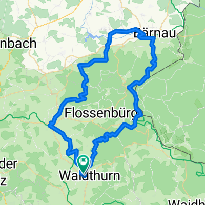
2015.04_ Haselranken-Kalter Baum-Haselranken
A cycling route starting in Waldthurn, Bavaria, Germany.
Overview
About this route
Sunday, 12.04.2015 Beautiful spring ride
- -:--
- Duration
- 42.4 km
- Distance
- 346 m
- Ascent
- 346 m
- Descent
- ---
- Avg. speed
- ---
- Max. altitude

Route quality
Waytypes & surfaces along the route
Waytypes
Path
16.1 km
(38 %)
Quiet road
12.7 km
(30 %)
Surfaces
Paved
33.9 km
(80 %)
Unpaved
8.5 km
(20 %)
Asphalt
33.9 km
(80 %)
Gravel
4.7 km
(11 %)
Continue with Bikemap
Use, edit, or download this cycling route
You would like to ride 2015.04_ Haselranken-Kalter Baum-Haselranken or customize it for your own trip? Here is what you can do with this Bikemap route:
Free features
- Save this route as favorite or in collections
- Copy & plan your own version of this route
- Sync your route with Garmin or Wahoo
Premium features
Free trial for 3 days, or one-time payment. More about Bikemap Premium.
- Navigate this route on iOS & Android
- Export a GPX / KML file of this route
- Create your custom printout (try it for free)
- Download this route for offline navigation
Discover more Premium features.
Get Bikemap PremiumFrom our community
Other popular routes starting in Waldthurn
 2015.05_360 ° Panoramatour
- Distance
- 36.6 km
- Ascent
- 456 m
- Descent
- 456 m
- Location
- Waldthurn, Bavaria, Germany
 2025.06.01_E_Heim-Irlhof-RW-Waldau-Neumühle-KV VOH-VOH-Platte-Pleystein-Bibershof-F´berg-Schinderweg-Hartingerhütte-Wampenhof-Spielberg-Heim
- Distance
- 41 km
- Ascent
- 781 m
- Descent
- 781 m
- Location
- Waldthurn, Bavaria, Germany
 Route 4 - Bocklweg Haselranken - Pleystein
- Distance
- 16.1 km
- Ascent
- 172 m
- Descent
- 180 m
- Location
- Waldthurn, Bavaria, Germany
 2015.04_ Haselranken-Kalter Baum-Haselranken
- Distance
- 42.4 km
- Ascent
- 346 m
- Descent
- 346 m
- Location
- Waldthurn, Bavaria, Germany
 Route 5 - Haselranken - KZ Flossenbürg
- Distance
- 9.9 km
- Ascent
- 278 m
- Descent
- 138 m
- Location
- Waldthurn, Bavaria, Germany
 2025.06.15_E_Heim-Woppenrieth-Planerer Höhe-Silberhütte-Naab/RW-Bärnau-Naab/RW-Plößberg-Haselstein/RW-Floß-RW-Otti-Heim
- Distance
- 58.5 km
- Ascent
- 1,047 m
- Descent
- 1,047 m
- Location
- Waldthurn, Bavaria, Germany
 2025.09.07_E_Heim-Irlhof-RW-VOH-VOH Baugebiet-Hütbrunnenweg-Altenstadt/Eisdiele-Schwarzenbachweg-Heim
- Distance
- 24.1 km
- Ascent
- 308 m
- Descent
- 308 m
- Location
- Waldthurn, Bavaria, Germany
 2025.08.03_E_Heim-Irlhof-RW-Floss/Eisdiele und wieder zurück
- Distance
- 26.3 km
- Ascent
- 201 m
- Descent
- 199 m
- Location
- Waldthurn, Bavaria, Germany
Open it in the app