

Doberlug-Elsterwerda (Brandbg-Rundt. T3)
A cycling route starting in Doberlug-Kirchhain, Brandenburg, Germany.
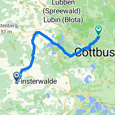
Overview
About this route
Third part of the Brandenburg round tour
Paved bike paths, quiet side streets, a few kilometers of gravel road and tank track roads. And a few short but steep climbs. Definitely visit the castle inn in Sallgast. In Lauchhammer, it's pretty dead. Decent food was only available at Marktkauf. Best to quickly move on to Elsterwerda. The Weißes Roß hotel is top-notch in all respects.
- -:--
- Duration
- 74.7 km
- Distance
- 164 m
- Ascent
- 171 m
- Descent
- ---
- Avg. speed
- 158 m
- Max. altitude
Route quality
Waytypes & surfaces along the route
Waytypes
Track
14.9 km
(20 %)
Road
14.2 km
(19 %)
Surfaces
Paved
58.3 km
(78 %)
Unpaved
5.2 km
(7 %)
Asphalt
56.8 km
(76 %)
Gravel
2.2 km
(3 %)
Continue with Bikemap
Use, edit, or download this cycling route
You would like to ride Doberlug-Elsterwerda (Brandbg-Rundt. T3) or customize it for your own trip? Here is what you can do with this Bikemap route:
Free features
- Save this route as favorite or in collections
- Copy & plan your own version of this route
- Sync your route with Garmin or Wahoo
Premium features
Free trial for 3 days, or one-time payment. More about Bikemap Premium.
- Navigate this route on iOS & Android
- Export a GPX / KML file of this route
- Create your custom printout (try it for free)
- Download this route for offline navigation
Discover more Premium features.
Get Bikemap PremiumFrom our community
Other popular routes starting in Doberlug-Kirchhain
 20170618_125257.gpx
- Distance
- 36.1 km
- Ascent
- 132 m
- Descent
- 133 m
- Location
- Doberlug-Kirchhain, Brandenburg, Germany
 Doberlug-Elsterwerda (Brandbg-Rundt. T3)
- Distance
- 74.7 km
- Ascent
- 164 m
- Descent
- 171 m
- Location
- Doberlug-Kirchhain, Brandenburg, Germany
 BikeComputer Aufnahme
- Distance
- 1.5 km
- Ascent
- 4 m
- Descent
- 0 m
- Location
- Doberlug-Kirchhain, Brandenburg, Germany
 Trittsteine der Bergbaugeschichte
- Distance
- 28.1 km
- Ascent
- 97 m
- Descent
- 99 m
- Location
- Doberlug-Kirchhain, Brandenburg, Germany
 GEHEIM TdG 2012 Tag 1 plus30km
- Distance
- 72.7 km
- Ascent
- 90 m
- Descent
- 132 m
- Location
- Doberlug-Kirchhain, Brandenburg, Germany
 Bahnhofstraße 25A, Doberlug-Kirchhain nach Hoppegarten 14, Zossen
- Distance
- 93.6 km
- Ascent
- 283 m
- Descent
- 345 m
- Location
- Doberlug-Kirchhain, Brandenburg, Germany
 ElbeElster2
- Distance
- 19.7 km
- Ascent
- 67 m
- Descent
- 75 m
- Location
- Doberlug-Kirchhain, Brandenburg, Germany
 Männertag
- Distance
- 30.2 km
- Ascent
- 864 m
- Descent
- 862 m
- Location
- Doberlug-Kirchhain, Brandenburg, Germany
Open it in the app