Wolfsegg - Höllohe
A cycling route starting in Wolfsegg, Bavaria, Germany.
Overview
About this route
Wolfsegg - Duggendorf - Kallmünz - Burglengenfeld- Höllohe
- -:--
- Duration
- 26.3 km
- Distance
- 152 m
- Ascent
- 195 m
- Descent
- ---
- Avg. speed
- ---
- Avg. speed
Route quality
Waytypes & surfaces along the route
Waytypes
Quiet road
10.2 km
(39 %)
Track
7.3 km
(28 %)
Surfaces
Paved
14 km
(53 %)
Unpaved
8.1 km
(31 %)
Asphalt
13.7 km
(52 %)
Gravel
6 km
(23 %)
Continue with Bikemap
Use, edit, or download this cycling route
You would like to ride Wolfsegg - Höllohe or customize it for your own trip? Here is what you can do with this Bikemap route:
Free features
- Save this route as favorite or in collections
- Copy & plan your own version of this route
- Sync your route with Garmin or Wahoo
Premium features
Free trial for 3 days, or one-time payment. More about Bikemap Premium.
- Navigate this route on iOS & Android
- Export a GPX / KML file of this route
- Create your custom printout (try it for free)
- Download this route for offline navigation
Discover more Premium features.
Get Bikemap PremiumFrom our community
Other popular routes starting in Wolfsegg
- Wolfsegg - Regensburg
- Distance
- 30.2 km
- Ascent
- 419 m
- Descent
- 481 m
- Location
- Wolfsegg, Bavaria, Germany
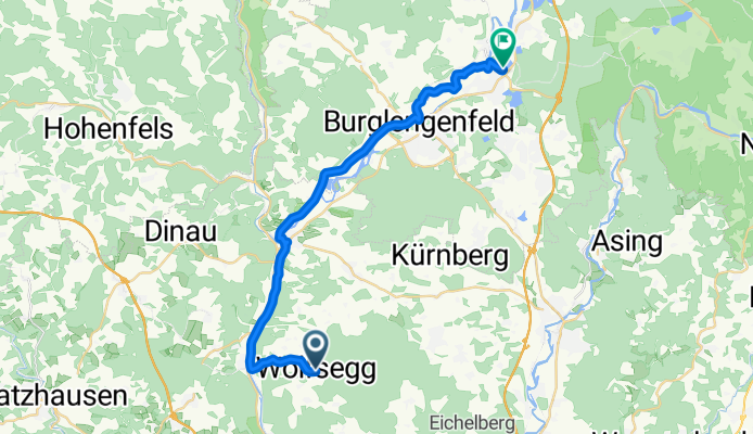
- Hohenwarth 6, Wolfsegg nach Wolfsegger Straße 4A
- Distance
- 35.2 km
- Ascent
- 985 m
- Descent
- 986 m
- Location
- Wolfsegg, Bavaria, Germany
- Wolfsegg_Regensburg
- Distance
- 49.9 km
- Ascent
- 351 m
- Descent
- 351 m
- Location
- Wolfsegg, Bavaria, Germany
- wolfsegg riedenburg
- Distance
- 32.3 km
- Ascent
- 648 m
- Descent
- 1,047 m
- Location
- Wolfsegg, Bavaria, Germany
- Moderate Route in Wolfsegg
- Distance
- 39.4 km
- Ascent
- 915 m
- Descent
- 917 m
- Location
- Wolfsegg, Bavaria, Germany
- Regensburg - Hamburg - ein Versuch gestoppt vom Elbhochwasser 2002
- Distance
- 540.6 km
- Ascent
- 1,103 m
- Descent
- 1,372 m
- Location
- Wolfsegg, Bavaria, Germany
- Steinsberg-Regenstauf-Marienthal-zurück
- Distance
- 42.3 km
- Ascent
- 250 m
- Descent
- 251 m
- Location
- Wolfsegg, Bavaria, Germany
- Unterbrunn - Parsberg
- Distance
- 36 km
- Ascent
- 550 m
- Descent
- 442 m
- Location
- Wolfsegg, Bavaria, Germany
Open it in the app