

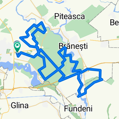
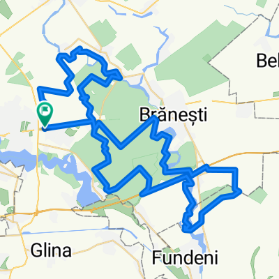
Inconjur Lac Cernica
A cycling route starting in Pantelimon, Ilfov, Romania.
Overview
About this route
Round Lake Cernica
Note:
In the first part of the forest, next to the water, across from the Monastery, there is a narrow path, it is possible to ride almost alongside the bike, but it is worth it.
As in all the forests around Bucharest, this route is not recommended in the rainy season, after days of rain, due to mud.
As in all forests around Bucharest, this route is best made early in the spring, until May, or late in the autumn, due to mosquitoes.
For a stop at the Cernica Monastery, please consider that bicycles are not allowed. They must be tied at the entrance, next to the access gate from the road. There is a guy at the entrance who is around, but insists that he is not responsible for them. (approx. 2015)
- 4 h 30 min
- Duration
- 26.5 km
- Distance
- 75 m
- Ascent
- 75 m
- Descent
- 5.9 km/h
- Avg. speed
- ---
- Max. altitude
Continue with Bikemap
Use, edit, or download this cycling route
You would like to ride Inconjur Lac Cernica or customize it for your own trip? Here is what you can do with this Bikemap route:
Free features
- Save this route as favorite or in collections
- Copy & plan your own version of this route
- Sync your route with Garmin or Wahoo
Premium features
Free trial for 3 days, or one-time payment. More about Bikemap Premium.
- Navigate this route on iOS & Android
- Export a GPX / KML file of this route
- Create your custom printout (try it for free)
- Download this route for offline navigation
Discover more Premium features.
Get Bikemap PremiumFrom our community
Other popular routes starting in Pantelimon
 DooRoti @ Cernica & Pasarea
- Distance
- 42.8 km
- Ascent
- 88 m
- Descent
- 94 m
- Location
- Pantelimon, Ilfov, Romania
 Ziua B - Traseul Epic
- Distance
- 65.1 km
- Ascent
- 129 m
- Descent
- 132 m
- Location
- Pantelimon, Ilfov, Romania
 Patelimon - Tătaru (2)
- Distance
- 139.6 km
- Ascent
- 108 m
- Descent
- 140 m
- Location
- Pantelimon, Ilfov, Romania
 Ziua B - traseul Epic 2014
- Distance
- 60.8 km
- Ascent
- 125 m
- Descent
- 125 m
- Location
- Pantelimon, Ilfov, Romania
 Tura prin Cernica
- Distance
- 41 km
- Ascent
- 123 m
- Descent
- 128 m
- Location
- Pantelimon, Ilfov, Romania
 Bucuresti - Cernica - Fundeni - Plataresti - Budesti - Crivat - Hotarele - Izvoarele - Teiusu - Mironesti - Colibasi - Vidra - 1 Decembrie - Bucuresti
- Distance
- 109.3 km
- Ascent
- 373 m
- Descent
- 380 m
- Location
- Pantelimon, Ilfov, Romania
 Bucuresti MTB Cernica Green 49 km (ADE 208) Bucuresti - Pd. Pustnicu - raul Pasarea - Pd. Cernica - Cernica - Bucuresti
- Distance
- 48.8 km
- Ascent
- 189 m
- Descent
- 192 m
- Location
- Pantelimon, Ilfov, Romania
 Ziua B - Traseul standard
- Distance
- 31.2 km
- Ascent
- 59 m
- Descent
- 60 m
- Location
- Pantelimon, Ilfov, Romania
Open it in the app