
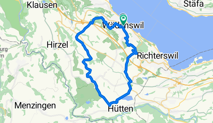
Wädenswil-Hütten-Wädenswil
A cycling route starting in Wädenswil / Dorf (Wädenswil), Canton of Zurich, Switzerland.
Overview
About this route
- -:--
- Duration
- 20 km
- Distance
- 435 m
- Ascent
- 325 m
- Descent
- ---
- Avg. speed
- 744 m
- Max. altitude
Route quality
Waytypes & surfaces along the route
Waytypes
Quiet road
12.8 km
(64 %)
Road
2.4 km
(12 %)
Surfaces
Paved
11.4 km
(57 %)
Unpaved
0.8 km
(4 %)
Asphalt
10.4 km
(52 %)
Paved (undefined)
1 km
(5 %)
Continue with Bikemap
Use, edit, or download this cycling route
You would like to ride Wädenswil-Hütten-Wädenswil or customize it for your own trip? Here is what you can do with this Bikemap route:
Free features
- Save this route as favorite or in collections
- Copy & plan your own version of this route
- Sync your route with Garmin or Wahoo
Premium features
Free trial for 3 days, or one-time payment. More about Bikemap Premium.
- Navigate this route on iOS & Android
- Export a GPX / KML file of this route
- Create your custom printout (try it for free)
- Download this route for offline navigation
Discover more Premium features.
Get Bikemap PremiumFrom our community
Other popular routes starting in Wädenswil / Dorf (Wädenswil)
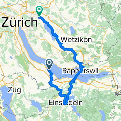
 Wädenswil Rapperswil
- Distance
- 14.4 km
- Ascent
- 50 m
- Descent
- 53 m
- Location
- Wädenswil / Dorf (Wädenswil), Canton of Zurich, Switzerland
 Ben's Summer ride
- Distance
- 137.5 km
- Ascent
- 2,513 m
- Descent
- 2,494 m
- Location
- Wädenswil / Dorf (Wädenswil), Canton of Zurich, Switzerland
 Bahnhofstrasse 4, Wädenswil nach Frickenstrasse 24, Dübendorf
- Distance
- 63.3 km
- Ascent
- 1,078 m
- Descent
- 1,039 m
- Location
- Wädenswil / Dorf (Wädenswil), Canton of Zurich, Switzerland
 Half Marathon (to Oberrieden)
- Distance
- 10 km
- Ascent
- 22 m
- Descent
- 18 m
- Location
- Wädenswil / Dorf (Wädenswil), Canton of Zurich, Switzerland
 Beine locker einfahren am Berg
- Distance
- 10.5 km
- Ascent
- 406 m
- Descent
- 80 m
- Location
- Wädenswil / Dorf (Wädenswil), Canton of Zurich, Switzerland
 Seeplatz, Wädenswil to Seestrasse 495, Zürich
- Distance
- 19.8 km
- Ascent
- 28 m
- Descent
- 28 m
- Location
- Wädenswil / Dorf (Wädenswil), Canton of Zurich, Switzerland
 Wädenswil Rapperswil Radwege
- Distance
- 14.2 km
- Ascent
- 65 m
- Descent
- 67 m
- Location
- Wädenswil / Dorf (Wädenswil), Canton of Zurich, Switzerland
 20140416 Hirzel-Zugerberg-Gottschalkenberg
- Distance
- 70.2 km
- Ascent
- 1,319 m
- Descent
- 1,319 m
- Location
- Wädenswil / Dorf (Wädenswil), Canton of Zurich, Switzerland
Open it in the app