

Aiguamolls de l'Emporda N Birdwatching
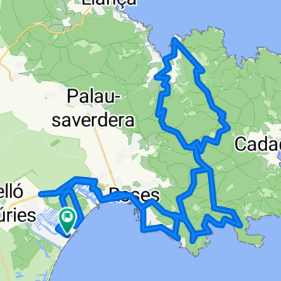
A cycling route starting in Empuriabrava, Catalonia, Spain.
Overview
About this route
Rundweg vom Camping Laguna aus an den Teich Vilaut, im Mai / Juni Chancen für Blauracke, Rotfussfalke, Rohrdommel und Schwarzstirnwürger.
Zwischen Mas Blanc und Barraca del pedra viele Gottesanbeterinnen und Heuschrecken.- -:--
- Duration
- 20.6 km
- Distance
- 24 m
- Ascent
- 20 m
- Descent
- ---
- Avg. speed
- ---
- Max. altitude
Route quality
Waytypes & surfaces along the route
Waytypes
Track
7.4 km
(36 %)
Quiet road
5.4 km
(26 %)
Surfaces
Paved
6 km
(29 %)
Unpaved
9.7 km
(47 %)
Gravel
6.2 km
(30 %)
Asphalt
5.4 km
(26 %)
Route highlights
Points of interest along the route
Point of interest after 6.3 km
Ende Radweg, 180 Grad nach rechts zum Kanal, unter einer Brücke auf die andere Seite der Nationalstrasse
Point of interest after 9.3 km
viele Gottesanbeterinnen
Point of interest after 9.6 km
häufig Rothühner
Point of interest after 10.9 km
Barraca de pedra, zerfallener Bauernhof, Geckos und (heimlich) die riesige Perleidechse (bis 80 cm lang)
Point of interest after 12.1 km
zwei riesige Korkeichen
Point of interest after 12.2 km
Hide: Vilaut Teich, evtl. Schwarzstirnwürger, viele Möwen und Enten
Point of interest after 12.4 km
Open fields: Blauracke und Rotfussfalke (Mai/Juni)
Point of interest after 13.7 km
Beobachtungsplatz für Rohrdommeln
Continue with Bikemap
Use, edit, or download this cycling route
You would like to ride Aiguamolls de l'Emporda N Birdwatching or customize it for your own trip? Here is what you can do with this Bikemap route:
Free features
- Save this route as favorite or in collections
- Copy & plan your own version of this route
- Sync your route with Garmin or Wahoo
Premium features
Free trial for 3 days, or one-time payment. More about Bikemap Premium.
- Navigate this route on iOS & Android
- Export a GPX / KML file of this route
- Create your custom printout (try it for free)
- Download this route for offline navigation
Discover more Premium features.
Get Bikemap PremiumFrom our community
Other popular routes starting in Empuriabrava
 Apuriabrava - offroad Runde
- Distance
- 38.2 km
- Ascent
- 71 m
- Descent
- 71 m
- Location
- Empuriabrava, Catalonia, Spain
 Empuriabrava-Porte de Selva-Empuriabrava
- Distance
- 78.6 km
- Ascent
- 1,021 m
- Descent
- 1,032 m
- Location
- Empuriabrava, Catalonia, Spain
 Parc Natural Cap Creus
- Distance
- 69.2 km
- Ascent
- 1,533 m
- Descent
- 1,450 m
- Location
- Empuriabrava, Catalonia, Spain
 Boadella Stausee
- Distance
- 103.6 km
- Ascent
- 859 m
- Descent
- 845 m
- Location
- Empuriabrava, Catalonia, Spain
 MTB-Tour Cala Montjoi-Cadaques-Puig Alt
- Distance
- 70.5 km
- Ascent
- 837 m
- Descent
- 837 m
- Location
- Empuriabrava, Catalonia, Spain
 Aiguamolls de l'Emporda N Birdwatching
- Distance
- 20.6 km
- Ascent
- 24 m
- Descent
- 20 m
- Location
- Empuriabrava, Catalonia, Spain
 Ruta dels Aiguamolls cde l'Empordà (llarga)
- Distance
- 37.4 km
- Ascent
- 43 m
- Descent
- 41 m
- Location
- Empuriabrava, Catalonia, Spain
 EmpuriaBrava -Punta Falconera
- Distance
- 31 km
- Ascent
- 460 m
- Descent
- 456 m
- Location
- Empuriabrava, Catalonia, Spain
Open it in the app