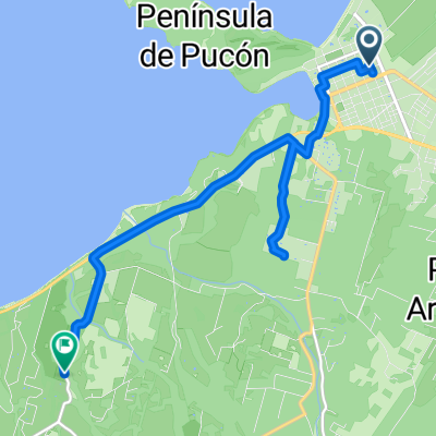
RUta xtream paque Nacional Huerquehue
- 41.6 km
- 669 m
- 666 m
- Pucón, Región de la Araucanía, Chile
A cycling route starting in Pucón, Región de la Araucanía, Chile.
Overview
After breakfast, I say goodbye to Mr. Pohl and ride back over the gravel track to the Red Interlagos, as this route through the lake district is called here in Chile. Back on asphalt, the riding feels good again; today the weather is dreamlike once more, with clear blue skies for days, hardly any wind, and pleasant temperatures, absolutely un-Patagonian, as Mr. Pohl also confirmed to me. Around midday, I reach Pucón; after successfully 'robbing' a bank, I take a break and meet a German tour group on a three-week Chilean tour. Naturally, they marvel at me and ask where I'm from and where I'm going. Now I continue along the busy lakeside road of Lago Villarrica, with the sleeping giant always in view. Looking for a cozy campsite, I have no luck and end up in a B&B right on the lake with a balcony and a view of the volcano. It's not cheap, but what the heck. There's still time for a stroll through town.
created this 10 years ago
Route quality
Quiet road
17.6 km
(37 %)
Cycleway
3.3 km
(7 %)
Paved
30.9 km
(65 %)
Unpaved
13.3 km
(28 %)
Asphalt
19.5 km
(41 %)
Unpaved (undefined)
13.3 km
(28 %)
Continue with Bikemap
You would like to ride Lake District 7. Etappe Termas de Palguin - Villarrica or customize it for your own trip? Here is what you can do with this Bikemap route:
Free trial for 3 days, or one-time payment. More about Bikemap Premium.
Discover more Premium features.
Get Bikemap PremiumFrom our community
Open it in the app