

Rund um das Kirchseemoor
A cycling route starting in Greiling, Bavaria, Germany.
Overview
About this route
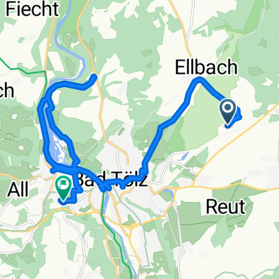
We start in front of the bike rental at the small Kursaal in Bad Tölz (Ludwigstraße 11 1/3) and head towards Isarsteg;
next we follow the yellow signs »Ellbach/ Sachsenkam« and reach the walls of the forest cemetery along Bairawieser Straße.
We cross this street and now have to conquer about 500 m of ascent on Feistweg, not turning off until we get to an asphalt path.
Here we turn left to Ellbach towards the main road. Now we cycle left, then right, following the yellow signs until we reach Kirchseemoor.
On the asphalt road, we now turn right until the left turn leads to the Reutberg Abbey.
Here the entrance to Sachsenkam or Reutberg Abbey is as follows: From the abbey, we continue north to the Kirchsee junction; first still on the road, then on a path until we reach the lakeshore. (Caution, do not ride up to the right!).
Now we go along the lakeshore for a bit (bathing possibility),
then through the moor to the yellow signs, passing Kogler Weiher (bathing possibility) over Abrain, Ellbach back to Bad Tölz.
… or in short, back to Sachsenkam or Reutberg Abbey: After Abrain, turn left towards Sachsenkam.
Translated, show original (German)- -:--
- Duration
- 21 km
- Distance
- 109 m
- Ascent
- 157 m
- Descent
- ---
- Avg. speed
- ---
- Max. altitude
Route quality
Waytypes & surfaces along the route
Waytypes
Track
8 km
(38 %)
Quiet road
7.3 km
(35 %)
Surfaces
Paved
11.1 km
(53 %)
Unpaved
8 km
(38 %)
Asphalt
9.4 km
(45 %)
Gravel
5.2 km
(25 %)
Continue with Bikemap
Use, edit, or download this cycling route
You would like to ride Rund um das Kirchseemoor or customize it for your own trip? Here is what you can do with this Bikemap route:
Free features
- Save this route as favorite or in collections
- Copy & plan your own version of this route
- Sync your route with Garmin or Wahoo
Premium features
Free trial for 3 days, or one-time payment. More about Bikemap Premium.
- Navigate this route on iOS & Android
- Export a GPX / KML file of this route
- Create your custom printout (try it for free)
- Download this route for offline navigation
Discover more Premium features.
Get Bikemap PremiumFrom our community
Other popular routes starting in Greiling
 Greiling Silvä Höhenweg
- Distance
- 66.8 km
- Ascent
- 470 m
- Descent
- 470 m
- Location
- Greiling, Bavaria, Germany
 Filzen Runde
- Distance
- 9.6 km
- Ascent
- 128 m
- Descent
- 128 m
- Location
- Greiling, Bavaria, Germany
 Beatbugs 1
- Distance
- 47.5 km
- Ascent
- 363 m
- Descent
- 363 m
- Location
- Greiling, Bavaria, Germany
 Greiling - Gaißach - Marienstein - Waakirchen - Reichersbeuern - Greiling
- Distance
- 24.2 km
- Ascent
- 234 m
- Descent
- 235 m
- Location
- Greiling, Bavaria, Germany
 Greiling - Seeshaupt - Greiling
- Distance
- 69.8 km
- Ascent
- 754 m
- Descent
- 756 m
- Location
- Greiling, Bavaria, Germany
 Obermühlberg 3, Bad Tölz nach Bergweg 5, Bad Tölz
- Distance
- 16.9 km
- Ascent
- 92 m
- Descent
- 114 m
- Location
- Greiling, Bavaria, Germany
 Greiling - Wildsteig
- Distance
- 70.6 km
- Ascent
- 960 m
- Descent
- 798 m
- Location
- Greiling, Bavaria, Germany
 Greiling - Marienstein - Tegernsee Rundweg
- Distance
- 43.8 km
- Ascent
- 490 m
- Descent
- 491 m
- Location
- Greiling, Bavaria, Germany
Open it in the app