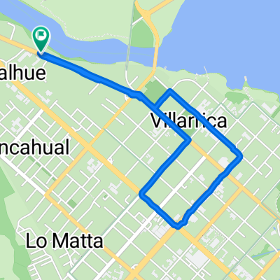
Lake District 8. Etappe Villarrica - Coñaripe
A cycling route starting in Villarrica, Región de la Araucanía, Chile.
Overview
About this route
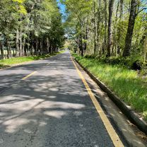
Breakfast is late, so I can sleep in and enjoy the sunrise over the lake with the volcano in the background; for that, the breakfast is quite abundant by Chilean standards. I buy some provisions and head towards Lago Calafquen, which I reach after a good hour on a hilly asphalt road. The lake is one of the warmest in the region, so I treat myself to a swimming break. At a beach restaurant, I take a rest and continue along the lake to Coñaripe; just beyond the town, I find a simple Eco-Camping with a great view of the lake and the sleeping Villarrica volcano.
- -:--
- Duration
- 52.5 km
- Distance
- 496 m
- Ascent
- 501 m
- Descent
- ---
- Avg. speed
- ---
- Max. altitude
Route quality
Waytypes & surfaces along the route
Waytypes
Road
9.4 km
(18 %)
Quiet road
7.3 km
(14 %)
Surfaces
Paved
40.9 km
(78 %)
Unpaved
10.5 km
(20 %)
Asphalt
24.1 km
(46 %)
Paved (undefined)
14.7 km
(28 %)
Continue with Bikemap
Use, edit, or download this cycling route
You would like to ride Lake District 8. Etappe Villarrica - Coñaripe or customize it for your own trip? Here is what you can do with this Bikemap route:
Free features
- Save this route as favorite or in collections
- Copy & plan your own version of this route
- Sync your route with Garmin or Wahoo
Premium features
Free trial for 3 days, or one-time payment. More about Bikemap Premium.
- Navigate this route on iOS & Android
- Export a GPX / KML file of this route
- Create your custom printout (try it for free)
- Download this route for offline navigation
Discover more Premium features.
Get Bikemap PremiumFrom our community
Other popular routes starting in Villarrica
Cervecería Cráter- Distance
- 20 km
- Ascent
- 219 m
- Descent
- 221 m
- Location
- Villarrica, Región de la Araucanía, Chile
Lake District 8. Etappe Villarrica - Coñaripe- Distance
- 52.5 km
- Ascent
- 496 m
- Descent
- 501 m
- Location
- Villarrica, Región de la Araucanía, Chile
Villarrica - Valdivia 2012- Distance
- 167.4 km
- Ascent
- 651 m
- Descent
- 915 m
- Location
- Villarrica, Región de la Araucanía, Chile
Villarica - Pucón- Distance
- 23.3 km
- Ascent
- 216 m
- Descent
- 210 m
- Location
- Villarrica, Región de la Araucanía, Chile
De Pasaje Pedregoso, Villarrica a Nuevo Porvenir, Villarrica- Distance
- 4.6 km
- Ascent
- 72 m
- Descent
- 15 m
- Location
- Villarrica, Región de la Araucanía, Chile
De Ernesto Wagner 995, Villarrica a Los Lirios 1250, Villarrica- Distance
- 4.5 km
- Ascent
- 38 m
- Descent
- 33 m
- Location
- Villarrica, Región de la Araucanía, Chile
Villarrica - Pucón #6 (7 Lagos Chile)- Distance
- 37.6 km
- Ascent
- 550 m
- Descent
- 548 m
- Location
- Villarrica, Región de la Araucanía, Chile
De Las Camelias 1295, Villarrica a Pasaje Los Lirios 1246, Villarrica- Distance
- 20.4 km
- Ascent
- 383 m
- Descent
- 384 m
- Location
- Villarrica, Región de la Araucanía, Chile
Open it in the app


