

Burghotel Am Hohen Bogen
A cycling route starting in Neukirchen, Bavaria, Germany.
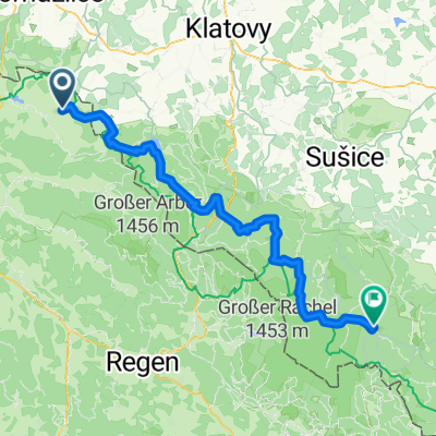
Overview
About this route
Burghotel Am Hohen Bogen Neukirchen beim Heilege Blut 5Km
- -:--
- Duration
- 4.5 km
- Distance
- 158 m
- Ascent
- 161 m
- Descent
- ---
- Avg. speed
- ---
- Max. altitude
Route quality
Waytypes & surfaces along the route
Waytypes
Quiet road
2.4 km
(54 %)
Track
1.5 km
(34 %)
Surfaces
Paved
1.8 km
(40 %)
Unpaved
0.4 km
(9 %)
Asphalt
0.9 km
(21 %)
Paved (undefined)
0.9 km
(19 %)
Route highlights
Points of interest along the route

Photo after 0 km
Burghotel Am Hohen Bogen
Continue with Bikemap
Use, edit, or download this cycling route
You would like to ride Burghotel Am Hohen Bogen or customize it for your own trip? Here is what you can do with this Bikemap route:
Free features
- Save this route as favorite or in collections
- Copy & plan your own version of this route
- Sync your route with Garmin or Wahoo
Premium features
Free trial for 3 days, or one-time payment. More about Bikemap Premium.
- Navigate this route on iOS & Android
- Export a GPX / KML file of this route
- Create your custom printout (try it for free)
- Download this route for offline navigation
Discover more Premium features.
Get Bikemap PremiumFrom our community
Other popular routes starting in Neukirchen
 Neukirchen b. h. Blut - Schrobenhausen
- Distance
- 222.9 km
- Ascent
- 382 m
- Descent
- 469 m
- Location
- Neukirchen, Bavaria, Germany
 Hinterbuchberger Straße, Eschlkam nach Kvilda, Kvilda
- Distance
- 82.2 km
- Ascent
- 2,201 m
- Descent
- 1,598 m
- Location
- Neukirchen, Bavaria, Germany
 Bayerwald Tag 4: Hohenbogen und Kaitersberg
- Distance
- 63.4 km
- Ascent
- 1,418 m
- Descent
- 1,418 m
- Location
- Neukirchen, Bavaria, Germany
 Neukirchen Hotel Donna W Seilbahn
- Distance
- 11.9 km
- Ascent
- 645 m
- Descent
- 478 m
- Location
- Neukirchen, Bavaria, Germany
 Nk02 Wander Freibachweg)
- Distance
- 7.7 km
- Ascent
- 610 m
- Descent
- 610 m
- Location
- Neukirchen, Bavaria, Germany
 Hoher-Bogen-Weg 1, Neukirchen beim Heiligen Blut nach Meisenweg 3–7, Cham
- Distance
- 30.7 km
- Ascent
- 143 m
- Descent
- 738 m
- Location
- Neukirchen, Bavaria, Germany
 GT2-6 Neukirchen-Waidhaus
- Distance
- 97.4 km
- Ascent
- 1,751 m
- Descent
- 1,650 m
- Location
- Neukirchen, Bavaria, Germany
 Route 3.Mai ObW
- Distance
- 25.5 km
- Ascent
- 660 m
- Descent
- 687 m
- Location
- Neukirchen, Bavaria, Germany
Open it in the app