

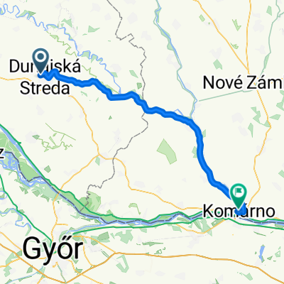
Csicsó - zöld út
A cycling route starting in Dunajská Streda, Trnava Region, Slovakia.
Overview
About this route
Alistál, Szap, Csicsó, Sárkánypuszta Alistál, 57 km
- -:--
- Duration
- 59.9 km
- Distance
- 15 m
- Ascent
- 18 m
- Descent
- ---
- Avg. speed
- ---
- Max. altitude

Route highlights
Points of interest along the route
Point of interest after 16.7 km
Veterán vendéglő
Point of interest after 32.8 km
Emlékpark
Point of interest after 33.1 km
Vendéglő - Nagy Géza fafaragásaival, finom, házias ételekkel
Point of interest after 33.5 km
Hét Vezér Park - faragott szobrok
Point of interest after 51.4 km
híd
Continue with Bikemap
Use, edit, or download this cycling route
You would like to ride Csicsó - zöld út or customize it for your own trip? Here is what you can do with this Bikemap route:
Free features
- Save this route as favorite or in collections
- Copy & plan your own version of this route
- Sync your route with Garmin or Wahoo
Premium features
Free trial for 3 days, or one-time payment. More about Bikemap Premium.
- Navigate this route on iOS & Android
- Export a GPX / KML file of this route
- Create your custom printout (try it for free)
- Download this route for offline navigation
Discover more Premium features.
Get Bikemap PremiumFrom our community
Other popular routes starting in Dunajská Streda
 DS-V.Dvorníky- Dunaj. Klátov- Dunaj. Mlyny
- Distance
- 10 km
- Ascent
- 9 m
- Descent
- 12 m
- Location
- Dunajská Streda, Trnava Region, Slovakia
 Rekreačný rad do Dunajská Streda
- Distance
- 43.9 km
- Ascent
- 31 m
- Descent
- 83 m
- Location
- Dunajská Streda, Trnava Region, Slovakia
 Nám Jána Kálvina, Dunaszerdahely - Dunajská Streda, Dunaszerdahely
- Distance
- 23.5 km
- Ascent
- 9 m
- Descent
- 12 m
- Location
- Dunajská Streda, Trnava Region, Slovakia
 Záhradnícka do Slovensko
- Distance
- 61.5 km
- Ascent
- 59 m
- Descent
- 59 m
- Location
- Dunajská Streda, Trnava Region, Slovakia
 Pomalá jazda Tomášikovo
- Distance
- 25.7 km
- Ascent
- 52 m
- Descent
- 52 m
- Location
- Dunajská Streda, Trnava Region, Slovakia
 Tour De Kukkonia FAMILY
- Distance
- 8.9 km
- Ascent
- 4 m
- Descent
- 4 m
- Location
- Dunajská Streda, Trnava Region, Slovakia
 Tour de Töltés
- Distance
- 68.3 km
- Ascent
- 49 m
- Descent
- 52 m
- Location
- Dunajská Streda, Trnava Region, Slovakia
 bike tour through Veľké Dvorníky
- Distance
- 14.9 km
- Ascent
- 0 m
- Descent
- 0 m
- Location
- Dunajská Streda, Trnava Region, Slovakia
Open it in the app