

Topasrunde
A cycling route starting in Schönheide, Saxony, Germany.
Overview
About this route
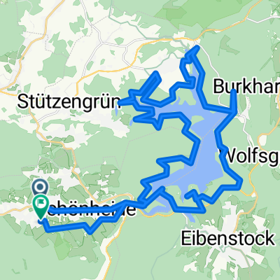
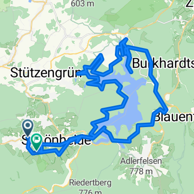
From Schönheiderhammer we access the ridge region via Torfhaus. We cross Carlsfeld and over the dam we reach the area of the Great Crane Lake. Continuing over the Black Pond, we pass Rammelsberg to Mühlleithen. We then make our way through Winselburg to the Topaz Rock. To avoid returning the same way, we head to Floßgraben and from there back to Mühlleithen. Now we ride through the valley of the upper Heroldsbach stream to Sachsengrund. From here we use the public road to Rautenkranz before heading back via forest paths to Wilzschhaus. Through the meadow path, we go to Altwiesenhaus and the last kilometers on the B 283.
- -:--
- Duration
- 56.8 km
- Distance
- 736 m
- Ascent
- 736 m
- Descent
- ---
- Avg. speed
- ---
- Max. altitude
Route quality
Waytypes & surfaces along the route
Waytypes
Track
42 km
(74 %)
Road
4.5 km
(8 %)
Surfaces
Paved
9.6 km
(17 %)
Unpaved
36.3 km
(64 %)
Gravel
18.7 km
(33 %)
Loose gravel
12.5 km
(22 %)
Continue with Bikemap
Use, edit, or download this cycling route
You would like to ride Topasrunde or customize it for your own trip? Here is what you can do with this Bikemap route:
Free features
- Save this route as favorite or in collections
- Copy & plan your own version of this route
- Sync your route with Garmin or Wahoo
Premium features
Free trial for 3 days, or one-time payment. More about Bikemap Premium.
- Navigate this route on iOS & Android
- Export a GPX / KML file of this route
- Create your custom printout (try it for free)
- Download this route for offline navigation
Discover more Premium features.
Get Bikemap PremiumFrom our community
Other popular routes starting in Schönheide
 Passhöhe Hefekloß
- Distance
- 12 km
- Ascent
- 345 m
- Descent
- 211 m
- Location
- Schönheide, Saxony, Germany
 Talsperre Eibenstock Rundweg
- Distance
- 38.8 km
- Ascent
- 1,110 m
- Descent
- 1,106 m
- Location
- Schönheide, Saxony, Germany
 Auersberg und Fichtelberg
- Distance
- 153.5 km
- Ascent
- 2,663 m
- Descent
- 2,663 m
- Location
- Schönheide, Saxony, Germany
 Schönheide- Auersberg
- Distance
- 31.6 km
- Ascent
- 847 m
- Descent
- 847 m
- Location
- Schönheide, Saxony, Germany
 Restful route in Schönheide
- Distance
- 16.9 km
- Ascent
- 247 m
- Descent
- 258 m
- Location
- Schönheide, Saxony, Germany
 Aue - Bad Schlema
- Distance
- 74.4 km
- Ascent
- 1,382 m
- Descent
- 1,383 m
- Location
- Schönheide, Saxony, Germany
 Talsperre Eibenstock Rundweg
- Distance
- 40.9 km
- Ascent
- 1,097 m
- Descent
- 1,081 m
- Location
- Schönheide, Saxony, Germany
 Moderate route in Schönheide
- Distance
- 20 km
- Ascent
- 403 m
- Descent
- 403 m
- Location
- Schönheide, Saxony, Germany
Open it in the app