
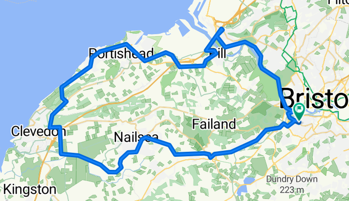
Portishead loop
A cycling route starting in Bristol, England, United Kingdom.
Overview
About this route
Portishead and back over the straight bridge
- -:--
- Duration
- 50.8 km
- Distance
- 251 m
- Ascent
- 250 m
- Descent
- ---
- Avg. speed
- ---
- Max. altitude
Route quality
Waytypes & surfaces along the route
Waytypes
Road
15 km
(29 %)
Quiet road
13.3 km
(26 %)
Surfaces
Paved
38.3 km
(75 %)
Unpaved
0 km
(<1 %)
Asphalt
37.3 km
(73 %)
Paved (undefined)
1 km
(2 %)
Continue with Bikemap
Use, edit, or download this cycling route
You would like to ride Portishead loop or customize it for your own trip? Here is what you can do with this Bikemap route:
Free features
- Save this route as favorite or in collections
- Copy & plan your own version of this route
- Sync your route with Garmin or Wahoo
Premium features
Free trial for 3 days, or one-time payment. More about Bikemap Premium.
- Navigate this route on iOS & Android
- Export a GPX / KML file of this route
- Create your custom printout (try it for free)
- Download this route for offline navigation
Discover more Premium features.
Get Bikemap PremiumFrom our community
Other popular routes starting in Bristol
 bristol
- Distance
- 9.7 km
- Ascent
- 38 m
- Descent
- 41 m
- Location
- Bristol, England, United Kingdom
 AvonKennett...Bristol To Reading
- Distance
- 149.3 km
- Ascent
- 244 m
- Descent
- 223 m
- Location
- Bristol, England, United Kingdom
 Bristol To Portishead
- Distance
- 16.9 km
- Ascent
- 84 m
- Descent
- 79 m
- Location
- Bristol, England, United Kingdom
 Pear Orchard, from Create
- Distance
- 54.7 km
- Ascent
- 377 m
- Descent
- 374 m
- Location
- Bristol, England, United Kingdom
 Stockwood Open Space, Dundry and Ashton Court
- Distance
- 31.8 km
- Ascent
- 308 m
- Descent
- 305 m
- Location
- Bristol, England, United Kingdom
 Portishead loop
- Distance
- 50.8 km
- Ascent
- 251 m
- Descent
- 250 m
- Location
- Bristol, England, United Kingdom
 weston-bristol
- Distance
- 75.2 km
- Ascent
- 151 m
- Descent
- 152 m
- Location
- Bristol, England, United Kingdom
 12th April lockdown getaway...
- Distance
- 35.4 km
- Ascent
- 219 m
- Descent
- 219 m
- Location
- Bristol, England, United Kingdom
Open it in the app