

4_TourRundumSchneverdingen
A cycling route starting in Schneverdingen, Lower Saxony, Germany.
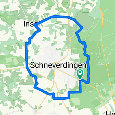
Overview
About this route
Rundtour um Schneverdingen zum Teil durch das Naturschutzgebiet Lüneburgerheide
(cloned from route 2938797)
- -:--
- Duration
- 22.3 km
- Distance
- 76 m
- Ascent
- 76 m
- Descent
- ---
- Avg. speed
- ---
- Max. altitude

Route quality
Waytypes & surfaces along the route
Waytypes
Quiet road
11.1 km
(50 %)
Track
7.8 km
(35 %)
Surfaces
Paved
10.8 km
(48 %)
Unpaved
8.9 km
(40 %)
Asphalt
8.7 km
(39 %)
Unpaved (undefined)
4.6 km
(21 %)
Continue with Bikemap
Use, edit, or download this cycling route
You would like to ride 4_TourRundumSchneverdingen or customize it for your own trip? Here is what you can do with this Bikemap route:
Free features
- Save this route as favorite or in collections
- Copy & plan your own version of this route
- Sync your route with Garmin or Wahoo
Premium features
Free trial for 3 days, or one-time payment. More about Bikemap Premium.
- Navigate this route on iOS & Android
- Export a GPX / KML file of this route
- Create your custom printout (try it for free)
- Download this route for offline navigation
Discover more Premium features.
Get Bikemap PremiumFrom our community
Other popular routes starting in Schneverdingen
 Heiderunde - Start an der KGS Schneverdingen
- Distance
- 28.7 km
- Ascent
- 100 m
- Descent
- 100 m
- Location
- Schneverdingen, Lower Saxony, Germany
 Melkhus Fintel
- Distance
- 28 km
- Ascent
- 58 m
- Descent
- 55 m
- Location
- Schneverdingen, Lower Saxony, Germany
 02-Schneverdingen-Hitzacker-102km
- Distance
- 101.3 km
- Ascent
- 608 m
- Descent
- 679 m
- Location
- Schneverdingen, Lower Saxony, Germany
 13.10.13
- Distance
- 43.5 km
- Ascent
- 216 m
- Descent
- 218 m
- Location
- Schneverdingen, Lower Saxony, Germany
 4_TourRundumSchneverdingen
- Distance
- 22.3 km
- Ascent
- 76 m
- Descent
- 76 m
- Location
- Schneverdingen, Lower Saxony, Germany
 Tag 4Schneverdingen-Höpen-Forst
- Distance
- 29.1 km
- Ascent
- 90 m
- Descent
- 90 m
- Location
- Schneverdingen, Lower Saxony, Germany
 Rund um Schneverdingen
- Distance
- 45.1 km
- Ascent
- 91 m
- Descent
- 90 m
- Location
- Schneverdingen, Lower Saxony, Germany
 Durch die Heide
- Distance
- 42.1 km
- Ascent
- 182 m
- Descent
- 180 m
- Location
- Schneverdingen, Lower Saxony, Germany
Open it in the app