

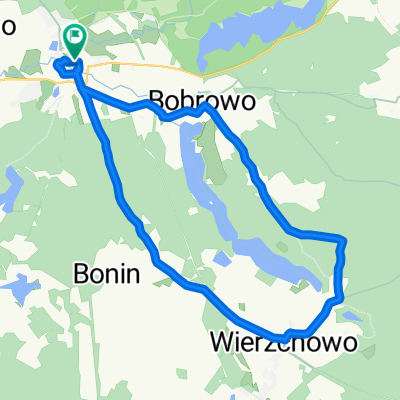
Szlak Zwiniętych Torów. Trasa Rowerowa Złocieniec - Połczyn Zdrój
A cycling route starting in Złocieniec, West Pomeranian Voivodeship, Poland.
Overview
About this route
Szlak Zwiniętych Torów.
Trasa Rowerowa Złocieniec - Połczyn Zdrój- -:--
- Duration
- 28.4 km
- Distance
- 133 m
- Ascent
- 168 m
- Descent
- ---
- Avg. speed
- ---
- Max. altitude

Route quality
Waytypes & surfaces along the route
Waytypes
Cycleway
28 km
(99 %)
Track
0.4 km
(1 %)
Undefined
0 km
(<1 %)
Surfaces
Paved
28 km
(99 %)
Asphalt
28 km
(99 %)
Undefined
0.4 km
(1 %)
Continue with Bikemap
Use, edit, or download this cycling route
You would like to ride Szlak Zwiniętych Torów. Trasa Rowerowa Złocieniec - Połczyn Zdrój or customize it for your own trip? Here is what you can do with this Bikemap route:
Free features
- Save this route as favorite or in collections
- Copy & plan your own version of this route
- Sync your route with Garmin or Wahoo
Premium features
Free trial for 3 days, or one-time payment. More about Bikemap Premium.
- Navigate this route on iOS & Android
- Export a GPX / KML file of this route
- Create your custom printout (try it for free)
- Download this route for offline navigation
Discover more Premium features.
Get Bikemap PremiumFrom our community
Other popular routes starting in Złocieniec
 jezioro kansko
- Distance
- 14.2 km
- Ascent
- 240 m
- Descent
- 247 m
- Location
- Złocieniec, West Pomeranian Voivodeship, Poland
 Cieszyno, Złocieniec do Cieszyńska 16–47, Złocieniec
- Distance
- 34.3 km
- Ascent
- 268 m
- Descent
- 264 m
- Location
- Złocieniec, West Pomeranian Voivodeship, Poland
 Złocieniec - Drawsko
- Distance
- 98.4 km
- Ascent
- 249 m
- Descent
- 265 m
- Location
- Złocieniec, West Pomeranian Voivodeship, Poland
 Złocieniec-Połczyn 70km
- Distance
- 69 km
- Ascent
- 427 m
- Descent
- 428 m
- Location
- Złocieniec, West Pomeranian Voivodeship, Poland
 Pętla dookoła jeziora Lubie Lubieszewo - Lubieszewo
- Distance
- 42.2 km
- Ascent
- 419 m
- Descent
- 415 m
- Location
- Złocieniec, West Pomeranian Voivodeship, Poland
 Dolina_Wasawy
- Distance
- 26.9 km
- Ascent
- 130 m
- Descent
- 130 m
- Location
- Złocieniec, West Pomeranian Voivodeship, Poland
 Gleboczek-Lubieszewo
- Distance
- 43.5 km
- Ascent
- 205 m
- Descent
- 206 m
- Location
- Złocieniec, West Pomeranian Voivodeship, Poland
 44A, Lubieszewo do 44A, Lubieszewo
- Distance
- 26.6 km
- Ascent
- 315 m
- Descent
- 312 m
- Location
- Złocieniec, West Pomeranian Voivodeship, Poland
Open it in the app