

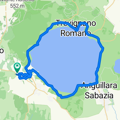
CALCATA E VALLE DEL TREJA
A cycling route starting in Bracciano, Lazio, Italy.
Overview
About this route
Lunghezza 40 km fino a Calcata; 60 km fino a Valle Muricana; possibilità di rientrare a Roma lungo la ciclabile Tevere Nord da Labaro prolungando ancora (circa 80 km)
Difficoltà dipendente dal ritorno; 3/5 o 4/5
Partenza castello di Bracciano
Arrivo Calcata (40km), oppure Valle Muricana (60 km), o rientro a Wheely (80 km)
punti di interesse: castello di Bracciano; lago di Bracciano; borgo di Anguillara Sabazia; valle del Treja; cascate di Monte Gelato; borgo di Calcata; parco naturale regionale di Vejo
contatti strutture: trattoria La Loggetta oppure la Latteria Del Gatto Nero
- -:--
- Duration
- 62.5 km
- Distance
- 450 m
- Ascent
- 634 m
- Descent
- ---
- Avg. speed
- ---
- Max. altitude

Route quality
Waytypes & surfaces along the route
Waytypes
Quiet road
16.9 km
(27 %)
Road
9.4 km
(15 %)
Surfaces
Paved
44.3 km
(71 %)
Asphalt
44.3 km
(71 %)
Undefined
18.1 km
(29 %)
Continue with Bikemap
Use, edit, or download this cycling route
You would like to ride CALCATA E VALLE DEL TREJA or customize it for your own trip? Here is what you can do with this Bikemap route:
Free features
- Save this route as favorite or in collections
- Copy & plan your own version of this route
- Sync your route with Garmin or Wahoo
Premium features
Free trial for 3 days, or one-time payment. More about Bikemap Premium.
- Navigate this route on iOS & Android
- Export a GPX / KML file of this route
- Create your custom printout (try it for free)
- Download this route for offline navigation
Discover more Premium features.
Get Bikemap PremiumFrom our community
Other popular routes starting in Bracciano
 Bracciano Sutra
- Distance
- 55.7 km
- Ascent
- 269 m
- Descent
- 269 m
- Location
- Bracciano, Lazio, Italy
 giro intorno
- Distance
- 41.4 km
- Ascent
- 451 m
- Descent
- 448 m
- Location
- Bracciano, Lazio, Italy
 Domenica 22km
- Distance
- 19.9 km
- Ascent
- 292 m
- Descent
- 266 m
- Location
- Bracciano, Lazio, Italy
 StracciacappelloRovineMonterano
- Distance
- 42.4 km
- Ascent
- 544 m
- Descent
- 539 m
- Location
- Bracciano, Lazio, Italy
 Bracciano - Tuscania
- Distance
- 60.3 km
- Ascent
- 430 m
- Descent
- 538 m
- Location
- Bracciano, Lazio, Italy
 Bracciano - San Martino al Cimino
- Distance
- 97.6 km
- Ascent
- 989 m
- Descent
- 989 m
- Location
- Bracciano, Lazio, Italy
 Route to Via Porto Recanati, Fiumicino
- Distance
- 41.9 km
- Ascent
- 252 m
- Descent
- 539 m
- Location
- Bracciano, Lazio, Italy
 Lago_Bracciano
- Distance
- 40.8 km
- Ascent
- 348 m
- Descent
- 348 m
- Location
- Bracciano, Lazio, Italy
Open it in the app