

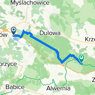
Trzebinia - Wygiełzów - Rudno - Trzebinia
A cycling route starting in Trzebinia, Lesser Poland Voivodeship, Poland.
Overview
About this route
Trzebinia/Młoszowa - Płaza - Wygiełzów - Rudno - Trzebinia/Młoszowa
- -:--
- Duration
- 44 km
- Distance
- 421 m
- Ascent
- 421 m
- Descent
- ---
- Avg. speed
- ---
- Max. altitude

Route quality
Waytypes & surfaces along the route
Waytypes
Quiet road
15.8 km
(36 %)
Track
12.8 km
(29 %)
Surfaces
Paved
26.8 km
(61 %)
Unpaved
14.1 km
(32 %)
Asphalt
26.8 km
(61 %)
Ground
5.7 km
(13 %)
Route highlights
Points of interest along the route
Point of interest after 0.3 km
Młoszowa - pałac i park
Point of interest after 6.8 km
Skałka triasowa k. Bolęcina
Point of interest after 8.8 km
Kościół Podwyższenia Krzyża Świętego z XVI w. w Płazie.
Point of interest after 10.3 km
Próba znalezienia szlaku do wąwozu Simota.
Point of interest after 16.3 km
Skansen Wygiełzów
Point of interest after 16.7 km
Zamek Lipowiec
Point of interest after 22.3 km
Miejsce piknikowe
Point of interest after 26.6 km
Źródło krasowe w Regulicach
Point of interest after 31.7 km
Zamek Tenczyn w Rudnie
Continue with Bikemap
Use, edit, or download this cycling route
You would like to ride Trzebinia - Wygiełzów - Rudno - Trzebinia or customize it for your own trip? Here is what you can do with this Bikemap route:
Free features
- Save this route as favorite or in collections
- Copy & plan your own version of this route
- Sync your route with Garmin or Wahoo
Premium features
Free trial for 3 days, or one-time payment. More about Bikemap Premium.
- Navigate this route on iOS & Android
- Export a GPX / KML file of this route
- Create your custom printout (try it for free)
- Download this route for offline navigation
Discover more Premium features.
Get Bikemap PremiumFrom our community
Other popular routes starting in Trzebinia
 Trzebinia - Wygiełzów - Rudno - Trzebinia
- Distance
- 44 km
- Ascent
- 421 m
- Descent
- 421 m
- Location
- Trzebinia, Lesser Poland Voivodeship, Poland
 Trzebinia - dolinki krakowskie
- Distance
- 64.2 km
- Ascent
- 1,041 m
- Descent
- 1,051 m
- Location
- Trzebinia, Lesser Poland Voivodeship, Poland
 Dworcowa 24, Trzebinia do Profesora Stefana Myczkowskiego 1, Kraków
- Distance
- 146.6 km
- Ascent
- 543 m
- Descent
- 624 m
- Location
- Trzebinia, Lesser Poland Voivodeship, Poland
 Puszcza Dulowska
- Distance
- 39.9 km
- Ascent
- 303 m
- Descent
- 302 m
- Location
- Trzebinia, Lesser Poland Voivodeship, Poland
 Głowackiego 91, Trzebinia do Rudno
- Distance
- 14.3 km
- Ascent
- 96 m
- Descent
- 49 m
- Location
- Trzebinia, Lesser Poland Voivodeship, Poland
 2. Jura Krakowsko - Częstochowska
- Distance
- 154.4 km
- Ascent
- 617 m
- Descent
- 674 m
- Location
- Trzebinia, Lesser Poland Voivodeship, Poland
 Czerwony szlak Trzebinia
- Distance
- 48.9 km
- Ascent
- 394 m
- Descent
- 394 m
- Location
- Trzebinia, Lesser Poland Voivodeship, Poland
 Zalew Chechło, Zamek Lipowiec, Puszcza Dulowska
- Distance
- 38.4 km
- Ascent
- 287 m
- Descent
- 285 m
- Location
- Trzebinia, Lesser Poland Voivodeship, Poland
Open it in the app