

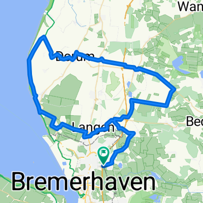
- Durchs Land Wursten - vom LTS Bremerhaven
A cycling route starting in Bremerhaven, City state Bremen, Germany.
Overview
About this route
Start/Ziel:
Tankstelle Laukait, Leher Straße 2a, 27619 Schiffdof-Spaden Telefon (0471) 86002 Die Kennzeichnungen mit den Wellen bedeuten, dass an dieser Stelle die Möglichkeit besteht über den Deich zufahren. <span style="font-size: 9pt; font-family: Arial;">Streckenmarkierung: -weißer Pfeil- auf rotem Grund</span> (cloned from route 231298)
- -:--
- Duration
- 76.9 km
- Distance
- 92 m
- Ascent
- 92 m
- Descent
- ---
- Avg. speed
- ---
- Max. altitude
Route quality
Waytypes & surfaces along the route
Waytypes
Quiet road
34.8 km
(45 %)
Road
25.5 km
(33 %)
Surfaces
Paved
64.9 km
(84 %)
Unpaved
0.2 km
(<1 %)
Asphalt
57.1 km
(74 %)
Paved (undefined)
6.8 km
(9 %)
Route highlights
Points of interest along the route
Point of interest after 23.9 km
Blick auf die Nordsee.
Point of interest after 45.2 km
Flughafen Nordholz
Continue with Bikemap
Use, edit, or download this cycling route
You would like to ride - Durchs Land Wursten - vom LTS Bremerhaven or customize it for your own trip? Here is what you can do with this Bikemap route:
Free features
- Save this route as favorite or in collections
- Copy & plan your own version of this route
- Sync your route with Garmin or Wahoo
Premium features
Free trial for 3 days, or one-time payment. More about Bikemap Premium.
- Navigate this route on iOS & Android
- Export a GPX / KML file of this route
- Create your custom printout (try it for free)
- Download this route for offline navigation
Discover more Premium features.
Get Bikemap PremiumFrom our community
Other popular routes starting in Bremerhaven
 - Durchs Land Wursten - vom LTS Bremerhaven
- Distance
- 76.9 km
- Ascent
- 92 m
- Descent
- 92 m
- Location
- Bremerhaven, City state Bremen, Germany
 Watt-Radlung
- Distance
- 72.4 km
- Ascent
- 0 m
- Descent
- 0 m
- Location
- Bremerhaven, City state Bremen, Germany
 Bremerhaven - Bederkesa
- Distance
- 60.4 km
- Ascent
- 107 m
- Descent
- 107 m
- Location
- Bremerhaven, City state Bremen, Germany
 Blummersberg - Alter Postweg
- Distance
- 31.7 km
- Ascent
- 61 m
- Descent
- 64 m
- Location
- Bremerhaven, City state Bremen, Germany
 HGA-Rück // Dedesdorf-Eidewarden // Freiladestraße 1, Bremerhaven nach Norderdeichstraße 3, Loxstedt
- Distance
- 12.4 km
- Ascent
- 9 m
- Descent
- 3 m
- Location
- Bremerhaven, City state Bremen, Germany
 - Zwischen dem Wind - vom LTS Bremerhaven
- Distance
- 73.2 km
- Ascent
- 123 m
- Descent
- 117 m
- Location
- Bremerhaven, City state Bremen, Germany
 Blummersberg - Alter Postweg BM
- Distance
- 31.8 km
- Ascent
- 61 m
- Descent
- 64 m
- Location
- Bremerhaven, City state Bremen, Germany
 Lange Ausfahrt durch Bremerhaven mit viel Grün und, Pausen
- Distance
- 35.4 km
- Ascent
- 22 m
- Descent
- 23 m
- Location
- Bremerhaven, City state Bremen, Germany
Open it in the app