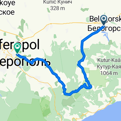
БЕЛОГОРСК - АРМЯНСКИЙ ХРАМ - "КАНЬОН КУЧУК - КАРАСУ"
A cycling route starting in Bilohirsk, Autonomous Republic of Crimea, Ukraine.
Overview
About this route
BELOGORSK - ARMENIAN TEMPLE - CANYON 'KUCZUK-KARASU'
- -:--
- Duration
- 60.2 km
- Distance
- 603 m
- Ascent
- 607 m
- Descent
- ---
- Avg. speed
- ---
- Max. altitude
Route quality
Waytypes & surfaces along the route
Waytypes
Road
17.5 km
(29 %)
Quiet road
15.1 km
(25 %)
Surfaces
Paved
33.1 km
(55 %)
Unpaved
6 km
(10 %)
Asphalt
33.1 km
(55 %)
Gravel
3 km
(5 %)
Continue with Bikemap
Use, edit, or download this cycling route
You would like to ride БЕЛОГОРСК - АРМЯНСКИЙ ХРАМ - "КАНЬОН КУЧУК - КАРАСУ" or customize it for your own trip? Here is what you can do with this Bikemap route:
Free features
- Save this route as favorite or in collections
- Copy & plan your own version of this route
- Sync your route with Garmin or Wahoo
Premium features
Free trial for 3 days, or one-time payment. More about Bikemap Premium.
- Navigate this route on iOS & Android
- Export a GPX / KML file of this route
- Create your custom printout (try it for free)
- Download this route for offline navigation
Discover more Premium features.
Get Bikemap PremiumFrom our community
Other popular routes starting in Bilohirsk
- belaya skala
- Distance
- 27.2 km
- Ascent
- 279 m
- Descent
- 281 m
- Location
- Bilohirsk, Autonomous Republic of Crimea, Ukraine
- КОК - АСАН - ЗЕЛЕНОГОРЬЕ - СУДАК
- Distance
- 69.7 km
- Ascent
- 1,135 m
- Descent
- 1,262 m
- Location
- Bilohirsk, Autonomous Republic of Crimea, Ukraine
- НОВОКЛЕНОВО ПЕЩЕРНЫЙ ГОРОД СЕВЕР КАРАБИ
- Distance
- 29.5 km
- Ascent
- 721 m
- Descent
- 720 m
- Location
- Bilohirsk, Autonomous Republic of Crimea, Ukraine
- БЕЛОГОРСК - СУДАК
- Distance
- 53.6 km
- Ascent
- 1,072 m
- Descent
- 1,198 m
- Location
- Bilohirsk, Autonomous Republic of Crimea, Ukraine
- БЕЛОГОРСК - АРМЯНСКИЙ ХРАМ - "КАНЬОН КУЧУК - КАРАСУ"
- Distance
- 60.2 km
- Ascent
- 603 m
- Descent
- 607 m
- Location
- Bilohirsk, Autonomous Republic of Crimea, Ukraine
- КОК - АСАН - ЮЖНОБЕРЕЖЬЕ
- Distance
- 112.6 km
- Ascent
- 1,502 m
- Descent
- 1,430 m
- Location
- Bilohirsk, Autonomous Republic of Crimea, Ukraine
- 4 сентября 2016 Белогорск Караби-Яйла Кара-Тау Красноселовка Белогорск
- Distance
- 71.1 km
- Ascent
- 1,018 m
- Descent
- 1,018 m
- Location
- Bilohirsk, Autonomous Republic of Crimea, Ukraine
- КАРАБИ - БОЛЬШИЕ ВОРОТА
- Distance
- 73.7 km
- Ascent
- 1,099 m
- Descent
- 1,128 m
- Location
- Bilohirsk, Autonomous Republic of Crimea, Ukraine
Open it in the app