

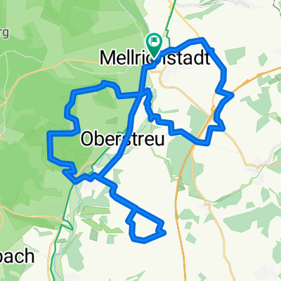
MET-A71
A cycling route starting in Mellrichstadt, Bavaria, Germany.
Overview
About this route
Alles Radweg, asphaltiert, geschottert oder Feldweg.
- -:--
- Duration
- 24.2 km
- Distance
- 210 m
- Ascent
- 210 m
- Descent
- ---
- Avg. speed
- ---
- Max. altitude
Route quality
Waytypes & surfaces along the route
Waytypes
Track
8.8 km
(36 %)
Quiet road
7.6 km
(31 %)
Surfaces
Paved
11.5 km
(47 %)
Unpaved
7 km
(29 %)
Asphalt
10.2 km
(42 %)
Gravel
4.5 km
(18 %)
Continue with Bikemap
Use, edit, or download this cycling route
You would like to ride MET-A71 or customize it for your own trip? Here is what you can do with this Bikemap route:
Free features
- Save this route as favorite or in collections
- Copy & plan your own version of this route
- Sync your route with Garmin or Wahoo
Premium features
Free trial for 3 days, or one-time payment. More about Bikemap Premium.
- Navigate this route on iOS & Android
- Export a GPX / KML file of this route
- Create your custom printout (try it for free)
- Download this route for offline navigation
Discover more Premium features.
Get Bikemap PremiumFrom our community
Other popular routes starting in Mellrichstadt
 frickenhäuser runde 2
- Distance
- 19.2 km
- Ascent
- 229 m
- Descent
- 229 m
- Location
- Mellrichstadt, Bavaria, Germany
 Mellrichstädter "Höhe"
- Distance
- 33.6 km
- Ascent
- 428 m
- Descent
- 428 m
- Location
- Mellrichstadt, Bavaria, Germany
 Grünes Band
- Distance
- 291.6 km
- Ascent
- 1,676 m
- Descent
- 1,221 m
- Location
- Mellrichstadt, Bavaria, Germany
 Truppenübungsplatz MET2
- Distance
- 16.3 km
- Ascent
- 196 m
- Descent
- 185 m
- Location
- Mellrichstadt, Bavaria, Germany
 Truppenübungsplatz MET
- Distance
- 18.5 km
- Ascent
- 141 m
- Descent
- 140 m
- Location
- Mellrichstadt, Bavaria, Germany
 BY_HE_Mellrichst_Milseburg_Obersinn
- Distance
- 137.3 km
- Ascent
- 957 m
- Descent
- 1,023 m
- Location
- Mellrichstadt, Bavaria, Germany
 Mellrichstadt-Hollstadt Rundkurs
- Distance
- 28.6 km
- Ascent
- 255 m
- Descent
- 242 m
- Location
- Mellrichstadt, Bavaria, Germany
 Rund um den Kreuzberg
- Distance
- 98.9 km
- Ascent
- 1,331 m
- Descent
- 1,331 m
- Location
- Mellrichstadt, Bavaria, Germany
Open it in the app