

medvědí česnek 27. 4. 14:21 2015
A cycling route starting in Bělá nad Radbuzou, Plzeň Region, Czechia.
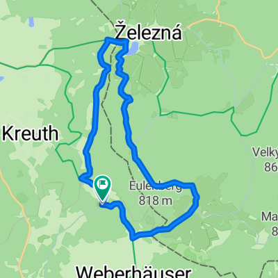
Overview
About this route
speed
- 2 h 30 min
- Duration
- 39.9 km
- Distance
- 524 m
- Ascent
- 527 m
- Descent
- 16 km/h
- Avg. speed
- ---
- Max. altitude

Route quality
Waytypes & surfaces along the route
Waytypes
Road
13.3 km
(33 %)
Track
11 km
(27 %)
Surfaces
Paved
19.3 km
(48 %)
Unpaved
4.6 km
(11 %)
Asphalt
14.7 km
(37 %)
Paved (undefined)
4.7 km
(12 %)
Route highlights
Points of interest along the route
Point of interest after 13.2 km
medvědí česnek
Continue with Bikemap
Use, edit, or download this cycling route
You would like to ride medvědí česnek 27. 4. 14:21 2015 or customize it for your own trip? Here is what you can do with this Bikemap route:
Free features
- Save this route as favorite or in collections
- Copy & plan your own version of this route
- Sync your route with Garmin or Wahoo
Premium features
Free trial for 3 days, or one-time payment. More about Bikemap Premium.
- Navigate this route on iOS & Android
- Export a GPX / KML file of this route
- Create your custom printout (try it for free)
- Download this route for offline navigation
Discover more Premium features.
Get Bikemap PremiumFrom our community
Other popular routes starting in Bělá nad Radbuzou
 Paneuropa Radweg Nürnberg-Prag Teil 4 CLONED FROM ROUTE 3513
- Distance
- 77.4 km
- Ascent
- 470 m
- Descent
- 662 m
- Location
- Bělá nad Radbuzou, Plzeň Region, Czechia
 Přejezd Českého lesa 2019
- Distance
- 63.5 km
- Ascent
- 811 m
- Descent
- 812 m
- Location
- Bělá nad Radbuzou, Plzeň Region, Czechia
 medvědí česnek 27. 4. 14:21 2015
- Distance
- 39.9 km
- Ascent
- 524 m
- Descent
- 527 m
- Location
- Bělá nad Radbuzou, Plzeň Region, Czechia
 Sautreiber gasse
- Distance
- 33.5 km
- Ascent
- 591 m
- Descent
- 589 m
- Location
- Bělá nad Radbuzou, Plzeň Region, Czechia
 1.PSI TRANCE 2019
- Distance
- 8 km
- Ascent
- 141 m
- Descent
- 141 m
- Location
- Bělá nad Radbuzou, Plzeň Region, Czechia
 Paneuropa radweg (Germany) CLONED FROM ROUTE 99456
- Distance
- 553.5 km
- Ascent
- 1,055 m
- Descent
- 1,438 m
- Location
- Bělá nad Radbuzou, Plzeň Region, Czechia
 30 vostrejch 2013
- Distance
- 30.2 km
- Ascent
- 320 m
- Descent
- 322 m
- Location
- Bělá nad Radbuzou, Plzeň Region, Czechia
 Friedrichshäng Rundfahrt
- Distance
- 15.6 km
- Ascent
- 373 m
- Descent
- 379 m
- Location
- Bělá nad Radbuzou, Plzeň Region, Czechia
Open it in the app