
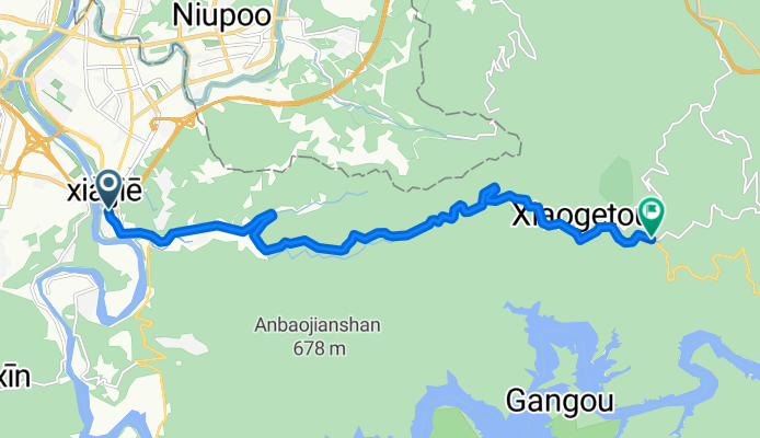
新店捷運站 → 北宜公路"海倫咖啡"
A cycling route starting in Banqiao District, Taipei, Taiwan.
Overview
About this route
<span style="font-family: Arial; font-size: 13px; white-space: pre;">新店捷運站 → 北宜公路"海倫咖啡"</span>
- -:--
- Duration
- 15.1 km
- Distance
- 752 m
- Ascent
- 241 m
- Descent
- ---
- Avg. speed
- 548 m
- Max. altitude

Route quality
Waytypes & surfaces along the route
Surfaces
Paved
15.1 km
(100 %)
Asphalt
15.1 km
(100 %)
Route highlights
Points of interest along the route
Point of interest after 15.1 km
北宜路上的海倫咖啡
Continue with Bikemap
Use, edit, or download this cycling route
You would like to ride 新店捷運站 → 北宜公路"海倫咖啡" or customize it for your own trip? Here is what you can do with this Bikemap route:
Free features
- Save this route as favorite or in collections
- Copy & plan your own version of this route
- Sync your route with Garmin or Wahoo
Premium features
Free trial for 3 days, or one-time payment. More about Bikemap Premium.
- Navigate this route on iOS & Android
- Export a GPX / KML file of this route
- Create your custom printout (try it for free)
- Download this route for offline navigation
Discover more Premium features.
Get Bikemap PremiumFrom our community
Other popular routes starting in Banqiao District
 新店-北宜-礁溪
- Distance
- 61.1 km
- Ascent
- 2,514 m
- Descent
- 2,331 m
- Location
- Banqiao District, Taipei, Taiwan
 新烏路-烏來
- Distance
- 13.9 km
- Ascent
- 447 m
- Descent
- 345 m
- Location
- Banqiao District, Taipei, Taiwan
 板橋-觀音山
- Distance
- 22 km
- Ascent
- 413 m
- Descent
- 76 m
- Location
- Banqiao District, Taipei, Taiwan
 捷運丹鳳站-新莊青年公園步道-牡丹心山-樟腦寮步道-十八份坑溪河濱步道-水源地公園-文青水園-牛角坡步道-福德宮-牛角坡橋-機捷體育大學站
- Distance
- 10.5 km
- Ascent
- 575 m
- Descent
- 350 m
- Location
- Banqiao District, Taipei, Taiwan
 三芝 巴拉卡
- Distance
- 75.1 km
- Ascent
- 1,019 m
- Descent
- 1,014 m
- Location
- Banqiao District, Taipei, Taiwan
 輪霸西濱200
- Distance
- 203.4 km
- Ascent
- 204 m
- Descent
- 203 m
- Location
- Banqiao District, Taipei, Taiwan
 西濱-八仙to白沙屯
- Distance
- 104.3 km
- Ascent
- 132 m
- Descent
- 133 m
- Location
- Banqiao District, Taipei, Taiwan
 北橫北宜路線
- Distance
- 232 km
- Ascent
- 8,795 m
- Descent
- 8,559 m
- Location
- Banqiao District, Taipei, Taiwan
Open it in the app