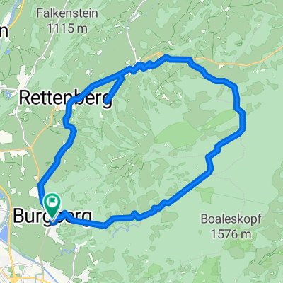
Tannheimer Tal
A cycling route starting in Burgberg, Bavaria, Germany.
Overview
About this route
Die Route hat zwei längere Anstiege, beide sind aber gut fahrbar.
Immer wieder wunderschöne Tiefblicke aufs Tannheimer Tal.
- -:--
- Duration
- 31.4 km
- Distance
- 1,004 m
- Ascent
- 1,067 m
- Descent
- ---
- Avg. speed
- 1,476 m
- Avg. speed
Route quality
Waytypes & surfaces along the route
Waytypes
Track
21.9 km
(70 %)
Quiet road
5 km
(16 %)
Surfaces
Paved
18.2 km
(58 %)
Unpaved
10.8 km
(34 %)
Asphalt
14.7 km
(47 %)
Gravel
10.4 km
(33 %)
Continue with Bikemap
Use, edit, or download this cycling route
You would like to ride Tannheimer Tal or customize it for your own trip? Here is what you can do with this Bikemap route:
Free features
- Save this route as favorite or in collections
- Copy & plan your own version of this route
- Sync your route with Garmin or Wahoo
Premium features
Free trial for 3 days, or one-time payment. More about Bikemap Premium.
- Navigate this route on iOS & Android
- Export a GPX / KML file of this route
- Create your custom printout (try it for free)
- Download this route for offline navigation
Discover more Premium features.
Get Bikemap PremiumFrom our community
Other popular routes starting in Burgberg
- Sorgschrofenrunde
- Distance
- 22.6 km
- Ascent
- 540 m
- Descent
- 558 m
- Location
- Burgberg, Bavaria, Germany
- Rund um den Grünten
- Distance
- 44.6 km
- Ascent
- 861 m
- Descent
- 720 m
- Location
- Burgberg, Bavaria, Germany
- Tannheimer Tal
- Distance
- 31.4 km
- Ascent
- 1,004 m
- Descent
- 1,067 m
- Location
- Burgberg, Bavaria, Germany
- Oberjoch-Tannheimer_Tal-Vilsalpsee
- Distance
- 41.9 km
- Ascent
- 1,056 m
- Descent
- 1,054 m
- Location
- Burgberg, Bavaria, Germany
- Sonthofen: Grünten
- Distance
- 8.1 km
- Ascent
- 752 m
- Descent
- 753 m
- Location
- Burgberg, Bavaria, Germany
- Dem Grünten ins Herz schauen - Runde an der Wandertrilogieroute Allgäu
- Distance
- 10.3 km
- Ascent
- 426 m
- Descent
- 426 m
- Location
- Burgberg, Bavaria, Germany
- ALPENÜBERQUERUNG Tannheimer Tal - Livigno 1. Tag
- Distance
- 99.2 km
- Ascent
- 1,366 m
- Descent
- 1,750 m
- Location
- Burgberg, Bavaria, Germany
- Rund um den Grünten
- Distance
- 34.6 km
- Ascent
- 571 m
- Descent
- 574 m
- Location
- Burgberg, Bavaria, Germany
Open it in the app