

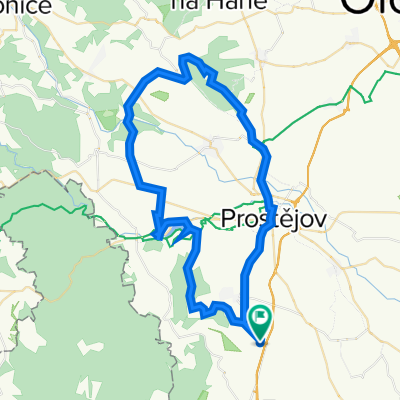
Myslejovice-Jedovnice-Rudice-Adamov-Křtiny-Ruprechtov-Pustiměř-Brodek u Prostějova-Určice-Myslejovice
A cycling route starting in Otaslavice, Olomoucký kraj, Czechia.
Overview
About this route
The more information you provide here, the more useful it will be for other users.* Route progress.* What is special about this route?* Why recommend this route?* What did you like most here?* Etc.
- -:--
- Duration
- 120.4 km
- Distance
- 2,097 m
- Ascent
- 2,139 m
- Descent
- ---
- Avg. speed
- 617 m
- Max. altitude

Route quality
Waytypes & surfaces along the route
Waytypes
Road
67.4 km
(56 %)
Track
28.9 km
(24 %)
Surfaces
Paved
67.4 km
(56 %)
Unpaved
3.6 km
(3 %)
Asphalt
60.2 km
(50 %)
Paved (undefined)
7.2 km
(6 %)
Continue with Bikemap
Use, edit, or download this cycling route
You would like to ride Myslejovice-Jedovnice-Rudice-Adamov-Křtiny-Ruprechtov-Pustiměř-Brodek u Prostějova-Určice-Myslejovice or customize it for your own trip? Here is what you can do with this Bikemap route:
Free features
- Save this route as favorite or in collections
- Copy & plan your own version of this route
- Split it into stages to create a multi-day tour
- Sync your route with Garmin or Wahoo
Premium features
Free trial for 3 days, or one-time payment. More about Bikemap Premium.
- Navigate this route on iOS & Android
- Export a GPX / KML file of this route
- Create your custom printout (try it for free)
- Download this route for offline navigation
Discover more Premium features.
Get Bikemap PremiumFrom our community
Other popular routes starting in Otaslavice
 Vřesovice-Kelčice-Vranovice-Vincencov-Myslejovice-Alojzov-Určice-Dětkovice-Vranovice-Kelčice-Vřesovice
- Distance
- 20.6 km
- Ascent
- 224 m
- Descent
- 221 m
- Location
- Otaslavice, Olomoucký kraj, Czechia
 Výlet do Modré
- Distance
- 113.8 km
- Ascent
- 1,283 m
- Descent
- 1,362 m
- Location
- Otaslavice, Olomoucký kraj, Czechia
 Vranovická
- Distance
- 29.2 km
- Ascent
- 363 m
- Descent
- 356 m
- Location
- Otaslavice, Olomoucký kraj, Czechia
 Myslejovice-Jedovnice-Rudice-Adamov-Křtiny-Ruprechtov-Pustiměř-Brodek u Prostějova-Určice-Myslejovice
- Distance
- 120.4 km
- Ascent
- 2,097 m
- Descent
- 2,139 m
- Location
- Otaslavice, Olomoucký kraj, Czechia
 Vranovice-Kosíř-Vranovice
- Distance
- 54.8 km
- Ascent
- 569 m
- Descent
- 569 m
- Location
- Otaslavice, Olomoucký kraj, Czechia
 Smržické vandr (CT 110 km) 2011
- Distance
- 135.1 km
- Ascent
- 0 m
- Descent
- 0 m
- Location
- Otaslavice, Olomoucký kraj, Czechia
 Vranovice-kolem VP-Vranovice
- Distance
- 71 km
- Ascent
- 814 m
- Descent
- 814 m
- Location
- Otaslavice, Olomoucký kraj, Czechia
 "Krátká na rozhlednu"
- Distance
- 7.1 km
- Ascent
- 92 m
- Descent
- 92 m
- Location
- Otaslavice, Olomoucký kraj, Czechia
Open it in the app