
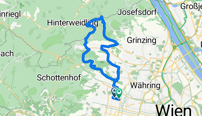
MTB im wienerwald
A cycling route starting in Vienna, Vienna, Austria.
Overview
About this route
- 2 h 20 min
- Duration
- 22.2 km
- Distance
- 562 m
- Ascent
- 560 m
- Descent
- 9.5 km/h
- Avg. speed
- ---
- Max. altitude

Route highlights
Points of interest along the route

Point of interest after 3 km

Point of interest after 8.1 km

Point of interest after 8.2 km
richtig steil!

Point of interest after 8.6 km
Häuserl am Roan

Point of interest after 11.2 km
Hermannskogel. Höchster Punkt Wiens

Point of interest after 11.7 km
Gewaltiger Ausblick!

Point of interest after 11.9 km
Spielplatz mit Bauer und Esel

Point of interest after 12 km
Agnesbrünnl

Point of interest after 12.6 km
rechts halten
Point of interest after 13.2 km
Ende einer coolen Abfahrt durch den Wald!

Point of interest after 16 km
Weinwanderweg
Point of interest after 18.5 km
Erdbeerstandl!
Continue with Bikemap
Use, edit, or download this cycling route
You would like to ride MTB im wienerwald or customize it for your own trip? Here is what you can do with this Bikemap route:
Free features
- Save this route as favorite or in collections
- Copy & plan your own version of this route
- Sync your route with Garmin or Wahoo
Premium features
Free trial for 3 days, or one-time payment. More about Bikemap Premium.
- Navigate this route on iOS & Android
- Export a GPX / KML file of this route
- Create your custom printout (try it for free)
- Download this route for offline navigation
Discover more Premium features.
Get Bikemap PremiumFrom our community
Other popular routes starting in Vienna
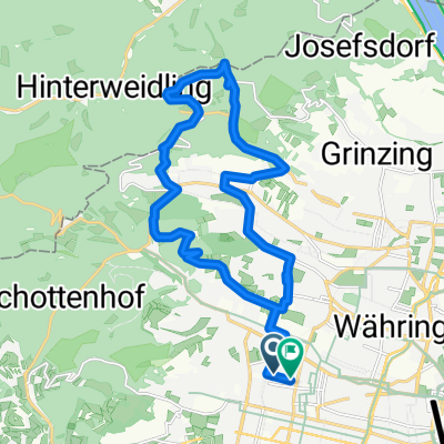 MTB im wienerwald
- Distance
- 22.2 km
- Ascent
- 562 m
- Descent
- 560 m
- Location
- Vienna, Vienna, Austria
 After_Work_Training_Standard
- Distance
- 69.7 km
- Ascent
- 1,149 m
- Descent
- 1,084 m
- Location
- Vienna, Vienna, Austria
 Naschmarkt/Klosterneuburg/St. Andrä/Exelberg
- Distance
- 58.1 km
- Ascent
- 481 m
- Descent
- 481 m
- Location
- Vienna, Vienna, Austria
 Donau-Radweg: Wien-Bratislava
- Distance
- 70.9 km
- Ascent
- 332 m
- Descent
- 340 m
- Location
- Vienna, Vienna, Austria
 Wien - Haslau an der Donau - Kittsee - Wien
- Distance
- 138.3 km
- Ascent
- 371 m
- Descent
- 423 m
- Location
- Vienna, Vienna, Austria
 Boku-Exelberg-Sophie-Riederb-TulbingK-Königstetten-St-Andrae-Hintersd-Boku
- Distance
- 84.2 km
- Ascent
- 1,189 m
- Descent
- 1,189 m
- Location
- Vienna, Vienna, Austria
 Kaisermühlen Nationalpark Donau-Auen-Lobau nach Seestadt Aspern
- Distance
- 34.9 km
- Ascent
- 235 m
- Descent
- 241 m
- Location
- Vienna, Vienna, Austria
 Vom Bikemap Office zum Kutschkermarkt
- Distance
- 5 km
- Ascent
- 64 m
- Descent
- 38 m
- Location
- Vienna, Vienna, Austria
Open it in the app