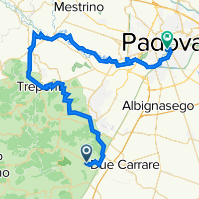
Monselice Tag 1 Venetien
A cycling route starting in Battaglia Terme, Veneto, Italy.
Overview
About this route
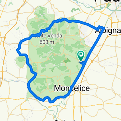
Donau TT33 - Monselice
- -:--
- Duration
- 27.8 km
- Distance
- 87 m
- Ascent
- 84 m
- Descent
- ---
- Avg. speed
- ---
- Avg. speed
Route highlights
Points of interest along the route
Point of interest after 7 km
Piazza Giuseppe Mazzini Torre Civica
Point of interest after 7.2 km
Castello Cini di Monselice
Point of interest after 7.4 km
Santa Giustina di Monselice
Point of interest after 7.8 km
Santuario di San Giorgio
Point of interest after 9.3 km
Duomo nuovo
Point of interest after 10 km
Ciesa di San Giacomo
Point of interest after 24.4 km
Villa Emo
Continue with Bikemap
Use, edit, or download this cycling route
You would like to ride Monselice Tag 1 Venetien or customize it for your own trip? Here is what you can do with this Bikemap route:
Free features
- Save this route as favorite or in collections
- Copy & plan your own version of this route
- Sync your route with Garmin or Wahoo
Premium features
Free trial for 3 days, or one-time payment. More about Bikemap Premium.
- Navigate this route on iOS & Android
- Export a GPX / KML file of this route
- Create your custom printout (try it for free)
- Download this route for offline navigation
Discover more Premium features.
Get Bikemap PremiumFrom our community
Other popular routes starting in Battaglia Terme
- Padua Tag 3 Venetien
- Distance
- 37.1 km
- Ascent
- 40 m
- Descent
- 33 m
- Location
- Battaglia Terme, Veneto, Italy
- BATTAGLIA
- Distance
- 17.6 km
- Ascent
- 6 m
- Descent
- 8 m
- Location
- Battaglia Terme, Veneto, Italy
- Euganei_01
- Distance
- 62.7 km
- Ascent
- 92 m
- Descent
- 89 m
- Location
- Battaglia Terme, Veneto, Italy
- partenza dal Castello del Catajo giro dei colli euganei
- Distance
- 65.5 km
- Ascent
- 157 m
- Descent
- 155 m
- Location
- Battaglia Terme, Veneto, Italy
- Battaglia - Monticelli - Arquà - Monselice - Battaglia
- Distance
- 24.8 km
- Ascent
- 235 m
- Descent
- 239 m
- Location
- Battaglia Terme, Veneto, Italy
- Giro dei Colli Euganei ciclabile E2 (itin. di Gianbianco)
- Distance
- 66.9 km
- Ascent
- 86 m
- Descent
- 87 m
- Location
- Battaglia Terme, Veneto, Italy
- Viale delle Terme 86, Galzignano Terme to Viale delle Terme 86, Galzignano Terme
- Distance
- 37.2 km
- Ascent
- 49 m
- Descent
- 60 m
- Location
- Battaglia Terme, Veneto, Italy
- Arqua Petrarca Tag 2 Venetien
- Distance
- 25.2 km
- Ascent
- 123 m
- Descent
- 119 m
- Location
- Battaglia Terme, Veneto, Italy
Open it in the app