

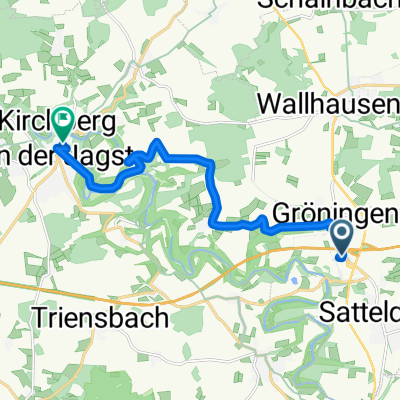
Horaffen Tour Die Jagst zw Crailsheim u. Kirchberg
A cycling route starting in Satteldorf, Baden-Wurttemberg, Germany.
Overview
About this route
Start - A good parking option is the Volksfestplatz or traveling by train.
Points of interest along the route:
-Craillsheim: Spitalkapelle Museum, Bullinger Eck, the Late Gothic parish church from 1398, the baroque town hall tower with a panoramic view of the city and the surrounding area, Diebsturm at the northeast corner.
-Gröningen: Hammer Forge Museum from 1804, Anhäuser Wall.
-Ellrichshausen: small private car museum in a listed railway building.
(cloned from route 2788037)
- -:--
- Duration
- 101.6 km
- Distance
- 656 m
- Ascent
- 634 m
- Descent
- ---
- Avg. speed
- ---
- Max. altitude
Route quality
Waytypes & surfaces along the route
Waytypes
Quiet road
39.6 km
(39 %)
Road
26.4 km
(26 %)
Surfaces
Paved
40.6 km
(40 %)
Unpaved
11.2 km
(11 %)
Asphalt
22.4 km
(22 %)
Paved (undefined)
18.3 km
(18 %)
Continue with Bikemap
Use, edit, or download this cycling route
You would like to ride Horaffen Tour Die Jagst zw Crailsheim u. Kirchberg or customize it for your own trip? Here is what you can do with this Bikemap route:
Free features
- Save this route as favorite or in collections
- Copy & plan your own version of this route
- Split it into stages to create a multi-day tour
- Sync your route with Garmin or Wahoo
Premium features
Free trial for 3 days, or one-time payment. More about Bikemap Premium.
- Navigate this route on iOS & Android
- Export a GPX / KML file of this route
- Create your custom printout (try it for free)
- Download this route for offline navigation
Discover more Premium features.
Get Bikemap PremiumFrom our community
Other popular routes starting in Satteldorf
 Kurze Runde
- Distance
- 9.5 km
- Ascent
- 58 m
- Descent
- 59 m
- Location
- Satteldorf, Baden-Wurttemberg, Germany
 E-Zeitfahren Crailsheim
- Distance
- 11.1 km
- Ascent
- 63 m
- Descent
- 63 m
- Location
- Satteldorf, Baden-Wurttemberg, Germany
 Satteldorf nach Rot am See
- Distance
- 14.8 km
- Ascent
- 136 m
- Descent
- 158 m
- Location
- Satteldorf, Baden-Wurttemberg, Germany
 Hohenloherundfahrt
- Distance
- 122.7 km
- Ascent
- 523 m
- Descent
- 523 m
- Location
- Satteldorf, Baden-Wurttemberg, Germany
 Horaffen Tour Die Jagst zw Crailsheim u. Kirchberg
- Distance
- 101.6 km
- Ascent
- 656 m
- Descent
- 634 m
- Location
- Satteldorf, Baden-Wurttemberg, Germany
 Marco-Polo-Straße 3, Satteldorf nach Auweg 15, Kirchberg an der Jagst
- Distance
- 11.3 km
- Ascent
- 80 m
- Descent
- 150 m
- Location
- Satteldorf, Baden-Wurttemberg, Germany
 BBR Tour 2013-04-14
- Distance
- 54.9 km
- Ascent
- 400 m
- Descent
- 400 m
- Location
- Satteldorf, Baden-Wurttemberg, Germany
 Pfaffenäckerweg 2, Satteldorf nach B13 48, Gunzenhausen
- Distance
- 65.9 km
- Ascent
- 742 m
- Descent
- 759 m
- Location
- Satteldorf, Baden-Wurttemberg, Germany
Open it in the app