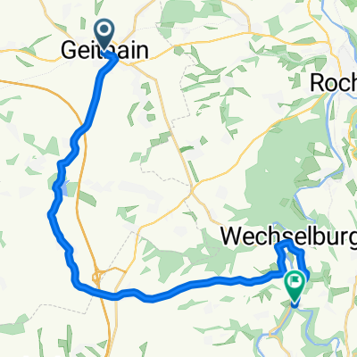
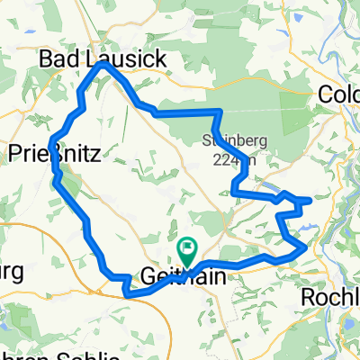
Geithain-Rochsburg-Burgstädt
- 35 km
- 381 m
- 302 m
- Geithain, Saxony, Germany
Start and finish: Geithain train station Route: Geithain – Niedergräfenhain – Frauendorf – Prießnitz – Trebishain – Bad Lausick – Buchheim – Colditzer Forest – Thierbaum – Nauenhain – Leutenhain – Schwarzbach – Doberenz – Königsfeld – Heide – Geithain Those traveling on foot or by bike through the land of the Red Porphyry repeatedly traverse idyllic landscapes. This tour proposal therefore aims to draw your attention to the tranquil nature of Kohrener Land and the Rochlitz Mulde Valley. The tour starts at the Geithain train station. From the Syhra Ecological Trail west of the town, an impressive wide view of Kohrener Land and the Leipzig lowlands opens up right at the start. Along the Eula stream valley, the tour passes through Niedergräfenhain and past the Hermsdorf Mill in Frauendorf. While enjoying the fresh forest air in the Frankenhain beech mixed forest, you pass by the Prießnitz forest swimming area on your way to Prießnitz. Here you will find one of the oldest farmers' council houses in Saxony. Continuing along the Altenburg-Colditz bike route (ACR) and past large fields, you reach Bad Lausick. Through the valley of the Heinersdorfer stream, you come to Buchheim and then to the Colditzer Forest, which with an area of around 1,800 hectares is one of the largest forest areas in Saxony. It is no wonder that, with its numerous cycling and hiking trails, it is one of the region's most popular recreational areas. After passing through Thierbaum, Nauenhain and Leutenhain, surrounded by fields and meadows, you drive past the Schwarzbach reservoir and reach Schwarzbach. A visit to the Schwarzbach Farmers' Museum here is highly recommended. Crossing the hilly and wide Weißbach valley, you then arrive in Doberenz. Along the way, there are multiple good panoramic views of Rochlitzer Berg over the Mulde Valley and into the surroundings of Colditz. In Doberenz, there is an opportunity to make a detour to the Weiditz Nature Conservation Station (accessible via federal highway 107). Along the Erlsbach stream, you reach Königsfeld with its beautiful castle pond. Continuing along the farm road towards Königsfeld-Heide and Geithain, there are several spots again offering a wonderful view into the valley of the Zwickauer Mulde around Rochlitz and to Rochlitzer Berg. Through the Struth Forest, you finally return to your starting point in Geithain. (cloned from route 2043916) (cloned from route 2733286)
Quiet road
22.3 km40 %Track
13.4 km24 %Paved
37.4 km(67 %)Unpaved
8.9 km(16 %)Asphalt
35.8 km64 %Gravel
6.1 km11 %Bauernmuseum Schwarzbach
Free trial for 3 days, or one-time payment. More about Bikemap Premium.
Discover more Premium features.
Get Bikemap PremiumOpen it in the app