
AA 002: Rittner Horn
A cycling route starting in Renon, Trentino-Alto Adige, Italy.
Overview
About this route
Dienstag, 21.04.2015
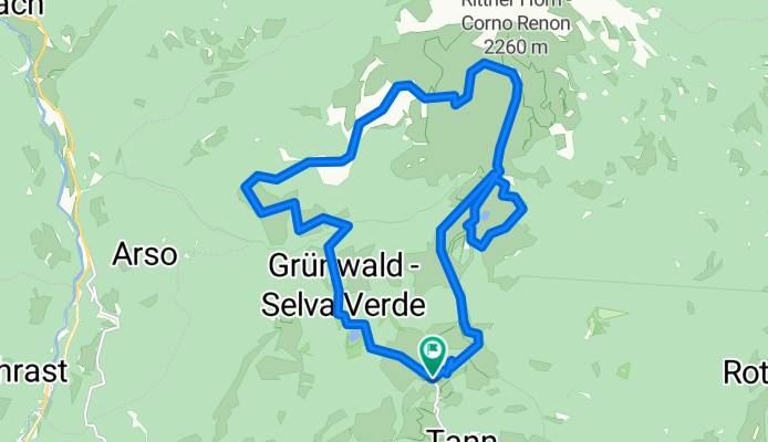
Hotel - Pkw - Pemmern - 1 - Klangweg/19 - Schwarzseespitze - Panoramaweg - Unterhorn - 1 - Rittner Horn - 2 - Gissmanner Hütte - 2 - Roaner - 7 - Gissmann - 7 - Roßwagen - 7 - Pemmern - Pkw - Hotel- -:--
- Duration
- 19.3 km
- Distance
- 938 m
- Ascent
- 939 m
- Descent
- ---
- Avg. speed
- ---
- Max. altitude
Continue with Bikemap
Use, edit, or download this cycling route
You would like to ride AA 002: Rittner Horn or customize it for your own trip? Here is what you can do with this Bikemap route:
Free features
- Save this route as favorite or in collections
- Copy & plan your own version of this route
- Sync your route with Garmin or Wahoo
Premium features
Free trial for 3 days, or one-time payment. More about Bikemap Premium.
- Navigate this route on iOS & Android
- Export a GPX / KML file of this route
- Create your custom printout (try it for free)
- Download this route for offline navigation
Discover more Premium features.
Get Bikemap PremiumFrom our community
Other popular routes starting in Renon
 Rittnerhorn PistenaufstiegBW9316
- Distance
- 5.4 km
- Ascent
- 719 m
- Descent
- 4 m
- Location
- Renon, Trentino-Alto Adige, Italy
 2019 Tag 3
- Distance
- 48.2 km
- Ascent
- 1,923 m
- Descent
- 1,864 m
- Location
- Renon, Trentino-Alto Adige, Italy
 2019 Tag 2
- Distance
- 40.2 km
- Ascent
- 1,589 m
- Descent
- 1,587 m
- Location
- Renon, Trentino-Alto Adige, Italy
 Kolbenstein-Patsch
- Distance
- 110.6 km
- Ascent
- 1,265 m
- Descent
- 1,476 m
- Location
- Renon, Trentino-Alto Adige, Italy
 probe Ameiser
- Distance
- 6 km
- Ascent
- 180 m
- Descent
- 179 m
- Location
- Renon, Trentino-Alto Adige, Italy
 Kemater Weiher
- Distance
- 4.3 km
- Ascent
- 150 m
- Descent
- 173 m
- Location
- Renon, Trentino-Alto Adige, Italy
 Ritten-Passo della mendola-Bozen- Seilbahn n.Ritten
- Distance
- 99.9 km
- Ascent
- 2,324 m
- Descent
- 3,345 m
- Location
- Renon, Trentino-Alto Adige, Italy
 Ritten-Penserjoch-Sterzing-Jaufenpass-St.Leonhard-Meran-Bozen-Seilbahn nach Ritten
- Distance
- 154.6 km
- Ascent
- 3,574 m
- Descent
- 4,578 m
- Location
- Renon, Trentino-Alto Adige, Italy
Open it in the app