

jezero konjic
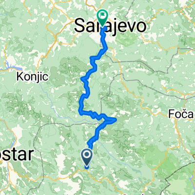
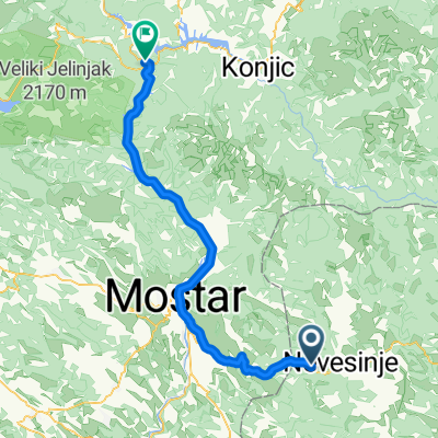
A cycling route starting in Nevesinje, Republika Srpska, Bosnia and Herzegovina.
Overview
About this route
Lake Konjic via Prenja
- -:--
- Duration
- 97.5 km
- Distance
- 1,341 m
- Ascent
- 2,127 m
- Descent
- ---
- Avg. speed
- ---
- Max. altitude

Continue with Bikemap
Use, edit, or download this cycling route
You would like to ride jezero konjic or customize it for your own trip? Here is what you can do with this Bikemap route:
Free features
- Save this route as favorite or in collections
- Copy & plan your own version of this route
- Split it into stages to create a multi-day tour
- Sync your route with Garmin or Wahoo
Premium features
Free trial for 3 days, or one-time payment. More about Bikemap Premium.
- Navigate this route on iOS & Android
- Export a GPX / KML file of this route
- Create your custom printout (try it for free)
- Download this route for offline navigation
Discover more Premium features.
Get Bikemap PremiumFrom our community
Other popular routes starting in Nevesinje
 Odzak Ruista Potoci
- Distance
- 64.1 km
- Ascent
- 710 m
- Descent
- 1,489 m
- Location
- Nevesinje, Republika Srpska, Bosnia and Herzegovina
 jezero konjic
- Distance
- 97.5 km
- Ascent
- 1,341 m
- Descent
- 2,127 m
- Location
- Nevesinje, Republika Srpska, Bosnia and Herzegovina
 Nevesinje - Podvelež - Mostar
- Distance
- 45.6 km
- Ascent
- 532 m
- Descent
- 1,366 m
- Location
- Nevesinje, Republika Srpska, Bosnia and Herzegovina
 Plužine - Sarajevo (via Bjelašnica)
- Distance
- 128.4 km
- Ascent
- 1,953 m
- Descent
- 2,559 m
- Location
- Nevesinje, Republika Srpska, Bosnia and Herzegovina
 Odzak Ruista Potoci
- Distance
- 64 km
- Ascent
- 706 m
- Descent
- 1,485 m
- Location
- Nevesinje, Republika Srpska, Bosnia and Herzegovina
 ewrr ewr ewr
- Distance
- 116.9 km
- Ascent
- 1,205 m
- Descent
- 1,589 m
- Location
- Nevesinje, Republika Srpska, Bosnia and Herzegovina
 Plužine - Sarajevo (via Trnovo)
- Distance
- 100.2 km
- Ascent
- 875 m
- Descent
- 1,599 m
- Location
- Nevesinje, Republika Srpska, Bosnia and Herzegovina
 D2011 R30
- Distance
- 75 km
- Ascent
- 652 m
- Descent
- 1,414 m
- Location
- Nevesinje, Republika Srpska, Bosnia and Herzegovina
Open it in the app