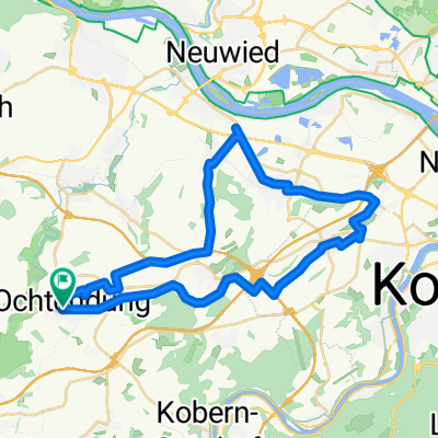
Radmarathon Ochtendung 218 km
A cycling route starting in Ochtendung, Rhineland-Palatinate, Germany.
Overview
About this route
Traditionelle Route des "Josef Oster" Radmarathon. Das Event findet jedes Jahr am 1. Mai statt und wird vom RST Ochtendung veranstaltet.
(cloned from route 34257)- -:--
- Duration
- 211.7 km
- Distance
- 1,723 m
- Ascent
- 1,723 m
- Descent
- ---
- Avg. speed
- ---
- Avg. speed
Route quality
Waytypes & surfaces along the route
Waytypes
Busy road
136.1 km
(64 %)
Road
25.4 km
(12 %)
Surfaces
Paved
175.7 km
(83 %)
Unpaved
9.8 km
(5 %)
Asphalt
173.8 km
(82 %)
Ground
6.1 km
(3 %)
Continue with Bikemap
Use, edit, or download this cycling route
You would like to ride Radmarathon Ochtendung 218 km or customize it for your own trip? Here is what you can do with this Bikemap route:
Free features
- Save this route as favorite or in collections
- Copy & plan your own version of this route
- Split it into stages to create a multi-day tour
- Sync your route with Garmin or Wahoo
Premium features
Free trial for 3 days, or one-time payment. More about Bikemap Premium.
- Navigate this route on iOS & Android
- Export a GPX / KML file of this route
- Create your custom printout (try it for free)
- Download this route for offline navigation
Discover more Premium features.
Get Bikemap PremiumFrom our community
Other popular routes starting in Ochtendung
- Eifelroute schwer
- Distance
- 78.3 km
- Ascent
- 0 m
- Descent
- 0 m
- Location
- Ochtendung, Rhineland-Palatinate, Germany
- RTF 41 Km
- Distance
- 37.4 km
- Ascent
- 304 m
- Descent
- 305 m
- Location
- Ochtendung, Rhineland-Palatinate, Germany
- Radmarathon Ochtendung 218 km CLONED FROM ROUTE 34257
- Distance
- 211.7 km
- Ascent
- 1,616 m
- Descent
- 1,616 m
- Location
- Ochtendung, Rhineland-Palatinate, Germany
- Ochtendung Radfahren
- Distance
- 205.5 km
- Ascent
- 2,576 m
- Descent
- 2,560 m
- Location
- Ochtendung, Rhineland-Palatinate, Germany
- CTF 25 KM
- Distance
- 23 km
- Ascent
- 250 m
- Descent
- 250 m
- Location
- Ochtendung, Rhineland-Palatinate, Germany
- RTF 152 geändert
- Distance
- 148.2 km
- Ascent
- 1,305 m
- Descent
- 1,305 m
- Location
- Ochtendung, Rhineland-Palatinate, Germany
- Kurze Eifelrundfahrt
- Distance
- 25.8 km
- Ascent
- 207 m
- Descent
- 207 m
- Location
- Ochtendung, Rhineland-Palatinate, Germany
- CTF-Ochtendung
- Distance
- 52.2 km
- Ascent
- 470 m
- Descent
- 470 m
- Location
- Ochtendung, Rhineland-Palatinate, Germany
Open it in the app