

Spechtensee
A cycling route starting in Tauplitz, Styria, Austria.
Overview
About this route
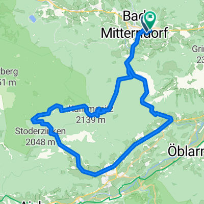
Sie starten in Bad Mitterndorf vor dem Gemeindeamt und biegen im Ortsteil Neuhofen nach links ab. Jetzt folgen Sie der Beschilderung >R19< vorbei an der Skiflugschanze Kulm zum Bahnhof Tauplitz. Vorbei am Bahnhof Tauplitz folgen Sie den Wegweisern nach Wörschachwald und zum Spechtensee. Eine Abkühlung im kleinen Moorsee wird Ihnen gut tun.
Nach einer Abfahrt über eine Schotterstraße erreichen Sie den Ort Wörschach. Durch die Ortschaft Wörschach, am Bahnhof vorbei, geradeaus über die Brücke der Enns. Von dort immer der Ennsentlang, Ennsradweg >R7< bis Trautenfels. Hier folgen Sie bergauf wieder der Markierung R19 bis Bad Mitterndorf.- -:--
- Duration
- 47.8 km
- Distance
- 577 m
- Ascent
- 570 m
- Descent
- ---
- Avg. speed
- ---
- Max. altitude
Route quality
Waytypes & surfaces along the route
Waytypes
Quiet road
34.3 km
(72 %)
Track
5 km
(10 %)
Surfaces
Paved
35.7 km
(75 %)
Unpaved
5.6 km
(12 %)
Asphalt
34.8 km
(73 %)
Unpaved (undefined)
4 km
(8 %)
Continue with Bikemap
Use, edit, or download this cycling route
You would like to ride Spechtensee or customize it for your own trip? Here is what you can do with this Bikemap route:
Free features
- Save this route as favorite or in collections
- Copy & plan your own version of this route
- Sync your route with Garmin or Wahoo
Premium features
Free trial for 3 days, or one-time payment. More about Bikemap Premium.
- Navigate this route on iOS & Android
- Export a GPX / KML file of this route
- Create your custom printout (try it for free)
- Download this route for offline navigation
Discover more Premium features.
Get Bikemap PremiumFrom our community
Other popular routes starting in Tauplitz
 Salzkammergut Radroute 1. Tag
- Distance
- 53.7 km
- Ascent
- 269 m
- Descent
- 576 m
- Location
- Tauplitz, Styria, Austria
 Bad Mitterndorf
- Distance
- 47.8 km
- Ascent
- 939 m
- Descent
- 936 m
- Location
- Tauplitz, Styria, Austria
 2020_Bad Mitterndorf-Grundlsee-Weissenbachalm-Mitterndorf
- Distance
- 59.3 km
- Ascent
- 1,180 m
- Descent
- 1,180 m
- Location
- Tauplitz, Styria, Austria
 Okolo Ödensee
- Distance
- 43.7 km
- Ascent
- 643 m
- Descent
- 643 m
- Location
- Tauplitz, Styria, Austria
 Tauplitzalm -> Tauplitz
- Distance
- 15.9 km
- Ascent
- 260 m
- Descent
- 984 m
- Location
- Tauplitz, Styria, Austria
 Thörl 3 nach Kurhausplatz 63, Bad Aussee
- Distance
- 31.9 km
- Ascent
- 454 m
- Descent
- 627 m
- Location
- Tauplitz, Styria, Austria
 Grundlsee
- Distance
- 60 km
- Ascent
- 763 m
- Descent
- 763 m
- Location
- Tauplitz, Styria, Austria
 Bad Mittendorf_VeihbergalmGROBMING-Salzastausee_BM_45_990
- Distance
- 45.3 km
- Ascent
- 958 m
- Descent
- 958 m
- Location
- Tauplitz, Styria, Austria
Open it in the app