

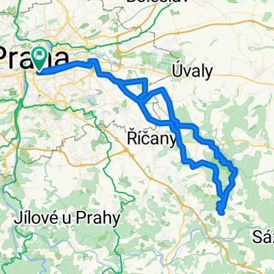
Vaclavske Nam -> Petriny
A cycling route starting in Old Town, Prague, Czechia.
Overview
About this route
Route from the top of Vaclavske Namesti to Petriny keeping off road or on quite roads as best possible.
There is an altrenative route up from veleslavin to Petriny, but it is very steep, but safer.
- -:--
- Duration
- 9 km
- Distance
- 178 m
- Ascent
- 33 m
- Descent
- ---
- Avg. speed
- 365 m
- Max. altitude
Route quality
Waytypes & surfaces along the route
Waytypes
Quiet road
3.5 km
(39 %)
Cycleway
1.8 km
(20 %)
Surfaces
Paved
5.9 km
(66 %)
Unpaved
0.3 km
(3 %)
Asphalt
5.1 km
(57 %)
Paving stones
0.5 km
(5 %)
Route highlights
Points of interest along the route
Point of interest after 2.9 km
Stick on the left hand side all the way up the hill as far as the tram stop Brucnice.
Point of interest after 4.3 km
To cross the road wait at the entrance to the AutoSkola for the lights up at the junction to change. There should be enough time to get across half way. The second half can be crossed either on the crossing or when traffic stops for a pedestrian on the crossing. If you wait a while there is always a gap in the traffic.
Continue with Bikemap
Use, edit, or download this cycling route
You would like to ride Vaclavske Nam -> Petriny or customize it for your own trip? Here is what you can do with this Bikemap route:
Free features
- Save this route as favorite or in collections
- Copy & plan your own version of this route
- Sync your route with Garmin or Wahoo
Premium features
Free trial for 3 days, or one-time payment. More about Bikemap Premium.
- Navigate this route on iOS & Android
- Export a GPX / KML file of this route
- Create your custom printout (try it for free)
- Download this route for offline navigation
Discover more Premium features.
Get Bikemap PremiumFrom our community
Other popular routes starting in Old Town
 Prag-Dresden
- Distance
- 217.4 km
- Ascent
- 169 m
- Descent
- 246 m
- Location
- Old Town, Prague, Czechia
 Prag-Berlin
- Distance
- 359.7 km
- Ascent
- 1,327 m
- Descent
- 1,470 m
- Location
- Old Town, Prague, Czechia
 Von Prag bis Nimburg
- Distance
- 57.3 km
- Ascent
- 250 m
- Descent
- 272 m
- Location
- Old Town, Prague, Czechia
 Girolibero: Praga Dresda
- Distance
- 173.2 km
- Ascent
- 1,469 m
- Descent
- 1,544 m
- Location
- Old Town, Prague, Czechia
 Prag nach Dresden
- Distance
- 225.3 km
- Ascent
- 1,381 m
- Descent
- 1,458 m
- Location
- Old Town, Prague, Czechia
 2012 Elberadweg_Prag-Berlin
- Distance
- 588.1 km
- Ascent
- 269 m
- Descent
- 426 m
- Location
- Old Town, Prague, Czechia
 Praha - Dubeč - Březí - Ondřejov - Zvánovice - Královice - Dubeč - Praha
- Distance
- 98.1 km
- Ascent
- 961 m
- Descent
- 898 m
- Location
- Old Town, Prague, Czechia
 From Prague to Nice
- Distance
- 1,525.9 km
- Ascent
- 18,717 m
- Descent
- 18,899 m
- Location
- Old Town, Prague, Czechia
Open it in the app