

Makowski - rekonesans
A cycling route starting in Stryszów, Lesser Poland Voivodeship, Poland.
Overview
About this route
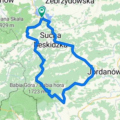
Stryszów - Łękawica - Lanckorona - Skawinki - Chełm - Stryszów
- -:--
- Duration
- 36.1 km
- Distance
- 729 m
- Ascent
- 722 m
- Descent
- ---
- Avg. speed
- ---
- Avg. speed

Route quality
Waytypes & surfaces along the route
Waytypes
Quiet road
25.3 km
(70 %)
Track
5.5 km
(15 %)
Surfaces
Paved
19.2 km
(53 %)
Unpaved
4.2 km
(12 %)
Asphalt
18.8 km
(52 %)
Ground
3.1 km
(8 %)
Continue with Bikemap
Use, edit, or download this cycling route
You would like to ride Makowski - rekonesans or customize it for your own trip? Here is what you can do with this Bikemap route:
Free features
- Save this route as favorite or in collections
- Copy & plan your own version of this route
- Sync your route with Garmin or Wahoo
Premium features
Free trial for 3 days, or one-time payment. More about Bikemap Premium.
- Navigate this route on iOS & Android
- Export a GPX / KML file of this route
- Create your custom printout (try it for free)
- Download this route for offline navigation
Discover more Premium features.
Get Bikemap PremiumFrom our community
Other popular routes starting in Stryszów
 17 mountain
- Distance
- 17.3 km
- Ascent
- 489 m
- Descent
- 490 m
- Location
- Stryszów, Lesser Poland Voivodeship, Poland
 Dookoła Mucharskiego
- Distance
- 43.3 km
- Ascent
- 827 m
- Descent
- 825 m
- Location
- Stryszów, Lesser Poland Voivodeship, Poland
 Stryszów do Zakrzów
- Distance
- 9.5 km
- Ascent
- 270 m
- Descent
- 194 m
- Location
- Stryszów, Lesser Poland Voivodeship, Poland
 Mucharz do Zawoji
- Distance
- 92.6 km
- Ascent
- 1,126 m
- Descent
- 1,168 m
- Location
- Stryszów, Lesser Poland Voivodeship, Poland
 Makowski - rekonesans
- Distance
- 36.1 km
- Ascent
- 729 m
- Descent
- 722 m
- Location
- Stryszów, Lesser Poland Voivodeship, Poland
 POGORZA_etap_prologowy_1
- Distance
- 48 km
- Ascent
- 1,114 m
- Descent
- 881 m
- Location
- Stryszów, Lesser Poland Voivodeship, Poland
![[GPX] Asiek - górki - Proko](https://media.bikemap.net/routes/9721999/staticmaps/in_c2ff1b2f-271c-4c72-8d5a-3794a8853044_400x400_bikemap-2021-3D-static.png) [GPX] Asiek - górki - Proko
[GPX] Asiek - górki - Proko- Distance
- 59.5 km
- Ascent
- 799 m
- Descent
- 1,002 m
- Location
- Stryszów, Lesser Poland Voivodeship, Poland
 Strszów-Sucha Beskidzka
- Distance
- 27.1 km
- Ascent
- 636 m
- Descent
- 633 m
- Location
- Stryszów, Lesser Poland Voivodeship, Poland
Open it in the app