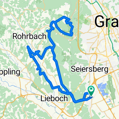
Schwarzlsee - Wildon - Kirchberg - St. Margarethen - Nestelbach - Schwarzlsee
A cycling route starting in Unterpremstätten, Styria, Austria.
Overview
About this route
- -:--
- Duration
- 88.4 km
- Distance
- 946 m
- Ascent
- 953 m
- Descent
- ---
- Avg. speed
- 505 m
- Avg. speed
Route quality
Waytypes & surfaces along the route
Waytypes
Busy road
53.9 km
(61 %)
Quiet road
10.9 km
(12 %)
Surfaces
Paved
72.7 km
(82 %)
Asphalt
71.2 km
(80 %)
Paving stones
0.8 km
(<1 %)
Continue with Bikemap
Use, edit, or download this cycling route
You would like to ride Schwarzlsee - Wildon - Kirchberg - St. Margarethen - Nestelbach - Schwarzlsee or customize it for your own trip? Here is what you can do with this Bikemap route:
Free features
- Save this route as favorite or in collections
- Copy & plan your own version of this route
- Sync your route with Garmin or Wahoo
Premium features
Free trial for 3 days, or one-time payment. More about Bikemap Premium.
- Navigate this route on iOS & Android
- Export a GPX / KML file of this route
- Create your custom printout (try it for free)
- Download this route for offline navigation
Discover more Premium features.
Get Bikemap PremiumFrom our community
Other popular routes starting in Unterpremstätten
- schwarzlsee-wundschuh-gantschenberg-preding-tobisegg-dobl-unterpremstätten
- Distance
- 37 km
- Ascent
- 346 m
- Descent
- 349 m
- Location
- Unterpremstätten, Styria, Austria
- Steiermark 2 - Westl. Steiermark
- Distance
- 56.4 km
- Ascent
- 535 m
- Descent
- 535 m
- Location
- Unterpremstätten, Styria, Austria
- Unterpremstätten-Wetzelsdorf-Preding-Lamberg-Steindorf-Wundschuh-Unterpremstätten
- Distance
- 44.4 km
- Ascent
- 0 m
- Descent
- 0 m
- Location
- Unterpremstätten, Styria, Austria
- Die West-Tour
- Distance
- 76.9 km
- Ascent
- 1,066 m
- Descent
- 1,064 m
- Location
- Unterpremstätten, Styria, Austria
- Die Südrunde
- Distance
- 55.7 km
- Ascent
- 159 m
- Descent
- 159 m
- Location
- Unterpremstätten, Styria, Austria
- Steiermark 3 - Südliche Mur
- Distance
- 76.7 km
- Ascent
- 172 m
- Descent
- 176 m
- Location
- Unterpremstätten, Styria, Austria
- Glocknerman 2014
- Distance
- 1,054.8 km
- Ascent
- 7,201 m
- Descent
- 7,201 m
- Location
- Unterpremstätten, Styria, Austria
- BikeMap Graz 70.3 v004
- Distance
- 88.3 km
- Ascent
- 990 m
- Descent
- 948 m
- Location
- Unterpremstätten, Styria, Austria