

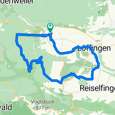
Löffingen - Möhringen
A cycling route starting in Löffingen, Baden-Wurttemberg, Germany.
Overview
About this route
Cycling tour from Löffingen, Kirnbergsee, Donaueschingen Castle, along the Danube to Möhringen, Gasthaus Löwen
- -:--
- Duration
- 52.1 km
- Distance
- 141 m
- Ascent
- 298 m
- Descent
- ---
- Avg. speed
- ---
- Max. altitude
Route quality
Waytypes & surfaces along the route
Waytypes
Track
19.3 km
(37 %)
Quiet road
13 km
(25 %)
Surfaces
Paved
40.6 km
(78 %)
Unpaved
6.8 km
(13 %)
Asphalt
39.1 km
(75 %)
Loose gravel
5.7 km
(11 %)
Continue with Bikemap
Use, edit, or download this cycling route
You would like to ride Löffingen - Möhringen or customize it for your own trip? Here is what you can do with this Bikemap route:
Free features
- Save this route as favorite or in collections
- Copy & plan your own version of this route
- Sync your route with Garmin or Wahoo
Premium features
Free trial for 3 days, or one-time payment. More about Bikemap Premium.
- Navigate this route on iOS & Android
- Export a GPX / KML file of this route
- Create your custom printout (try it for free)
- Download this route for offline navigation
Discover more Premium features.
Get Bikemap PremiumFrom our community
Other popular routes starting in Löffingen
 Wutachrundfahrt mit Wutach- und Schattenmühle
- Distance
- 46.5 km
- Ascent
- 621 m
- Descent
- 620 m
- Location
- Löffingen, Baden-Wurttemberg, Germany
 Durch Wald und Flur zur Wallfahrtskapelle zum „Witterschneekreuz“.
- Distance
- 11.2 km
- Ascent
- 88 m
- Descent
- 88 m
- Location
- Löffingen, Baden-Wurttemberg, Germany
 3 Tages Biketour Südschwarzwald für MTB von H.R.S.T.
- Distance
- 120 km
- Ascent
- 1,587 m
- Descent
- 2,115 m
- Location
- Löffingen, Baden-Wurttemberg, Germany
 Unnamed Road, Löffingen nach Florianweg 14, Bonndorf im Schwarzwald
- Distance
- 29 km
- Ascent
- 456 m
- Descent
- 516 m
- Location
- Löffingen, Baden-Wurttemberg, Germany
 bbb
bbb- Distance
- 22.9 km
- Ascent
- 325 m
- Descent
- 322 m
- Location
- Löffingen, Baden-Wurttemberg, Germany
 Öschradtour
- Distance
- 31.9 km
- Ascent
- 517 m
- Descent
- 505 m
- Location
- Löffingen, Baden-Wurttemberg, Germany
 Rötenbach: Ameisenpfad
- Distance
- 4.7 km
- Ascent
- 110 m
- Descent
- 109 m
- Location
- Löffingen, Baden-Wurttemberg, Germany
 Schwarzwaldrunde
- Distance
- 53.4 km
- Ascent
- 734 m
- Descent
- 698 m
- Location
- Löffingen, Baden-Wurttemberg, Germany
Open it in the app