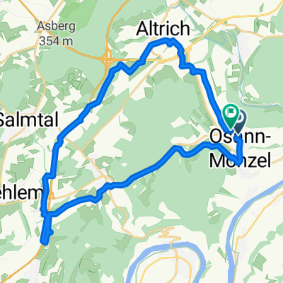
Osann-Monzel - Taben-Rodt
- 67.6 km
- 544 m
- 635 m
- Osann-Monzel, Rhineland-Palatinate, Germany
A cycling route starting in Osann-Monzel, Rhineland-Palatinate, Germany.
Overview
During infrastructure works for land consolidation, Roman pressing facilities from the 4th century and the 2nd century AD were discovered in 1985 and 1991, - not far from each other - on the edge of the famous vineyard 'Piesporter Goldtröpfchen'. The facility from the 4th century was restored faithfully to its original state. In total, this facility included a grape press, 7 basins, and several cellars. The size of the must basins and the storage capacity of the cellars suggest that the vineyard area of Piesport at the time already covered at least 60 hectares. The management of such an area and the operation of such a large facility were more suited to a state entity than a private business.
created this 10 years ago
Route quality
Track
5.6 km
61 %
Road
2.3 km
25 %
Paved
8.2 km
(89 %)
Unpaved
0.7 km
(8 %)
Asphalt
7.5 km
81 %
Paved (undefined)
0.7 km
8 %
Route highlights
Kirche
Kirche
Tourist-Information Kesten
Kirche
Unterhalb der Pfarrkirche legen täglich viermal die Fahrgastschiffe an. <br><br>
Denkmal
Hütte (H)
Weinstube am Domhof
Die Schiffsanlegestelle in Alt Piesport ist gegenüber dem Bürgerhaus bzw. neben dem Landgasthof "Alt Piesport" zu finden. <br><br>
Bei Wegebaumaßnahmen zur Flurbereinigung entdeckte man 1985 und 1991, - nicht weit voneinander entfernt - , am Rande der berühmten Weinlage "Piesporter Goldtröpfchen" röm. Kelteranlagen aus dem 4. Jh. bzw. 2. Jh. n. Chr. Die Kelteranlage des 4. Jahrhunderts wurde originalgetreu restauriert. Insgesam
Continue with Bikemap
You would like to ride Schiffswanderweg or customize it for your own trip? Here is what you can do with this Bikemap route:
Free trial for 3 days, or one-time payment. More about Bikemap Premium.
Discover more Premium features.
Get Bikemap PremiumFrom our community
Open it in the app