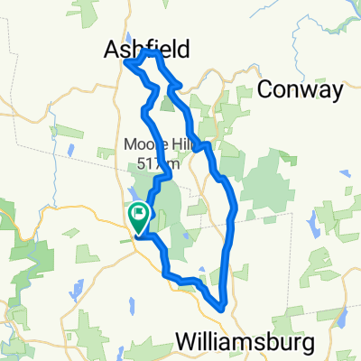
Ashfield Loop w/Chesterfield Gorge
- 52.1 km
- 849 m
- 852 m
- Chesterfield, Massachusetts, United States
A cycling route starting in Chesterfield, Massachusetts, United States.
Overview
Chesterfield Gorge is start. Turn Right into Ireland Street. Follow to stop. Turn Right onto route 143, Main Road. Follow 143 into Chesterfield Center. Davenport Child Care will be on your right after going through town center. First food stop. Continue on route 143. Turn Left onto Sugar Hill Road, go up hill past boy scout camp and turn right onto Old Chesterfield Road. When Old Chesterfield Road comes turns right, bear left onto Soaker Road. Follow into Goshen and it will become South Chesterfield Road. Followto the stop sign and turn left onto South Main Street. Follow to the stop sign and turn left onto route 9 West. Follow Route 9 through Goshen and Cummington into West Cummington. Turn Right into West Cummington onto West Main Street (signs for Windor Jams at corner) . West Cummington Congregational Church Parish House will be on your left for a food stop. continue onto West Main Street following it to the stop sign at the intersection of route 9. Turn left onto route 9 East, go down the hill and turn right onto West Cummington Road. Follow West Cummington Road to the junction of route 112. Go stright onto route 112 (staying on West Cummington Road) and follow it into Worthington where it will become Dingle Road. Stay on route 112 and follow it to Capen street. Turn left onto Capen street and follow it to the stop sign. Turn left onto route 143 and follow 143 into Chesterfield. Turn right onto Ireland stree (signs for the Chesterfield Gorge) and follow Ireland stree back to River road and the four seasons club on your left.
created this 10 years ago
Route quality
Road
10.5 km
(19 %)
Quiet road
3.3 km
(6 %)
Paved
18.7 km
(34 %)
Unpaved
2.2 km
(4 %)
Asphalt
18.7 km
(34 %)
Unpaved (undefined)
2.2 km
(4 %)
Undefined
34.2 km
(62 %)
Continue with Bikemap
You would like to ride Therese's Trek or customize it for your own trip? Here is what you can do with this Bikemap route:
Free trial for 3 days, or one-time payment. More about Bikemap Premium.
Discover more Premium features.
Get Bikemap PremiumFrom our community
Open it in the app