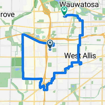
Milwaukee-southeast loop.
A cycling route starting in West Allis, Wisconsin, United States.
Overview
About this route
hank Aaron east. Oakleaf trail south and west. 68th-70th street home.
- 1 h 33 min
- Duration
- 30 km
- Distance
- 82 m
- Ascent
- 83 m
- Descent
- 19.3 km/h
- Avg. speed
- ---
- Max. altitude
Route quality
Waytypes & surfaces along the route
Waytypes
Quiet road
11.1 km
(37 %)
Path
9.3 km
(31 %)
Surfaces
Paved
22.5 km
(75 %)
Asphalt
12.9 km
(43 %)
Paved (undefined)
5.1 km
(17 %)
Continue with Bikemap
Use, edit, or download this cycling route
You would like to ride Milwaukee-southeast loop. or customize it for your own trip? Here is what you can do with this Bikemap route:
Free features
- Save this route as favorite or in collections
- Copy & plan your own version of this route
- Sync your route with Garmin or Wahoo
Premium features
Free trial for 3 days, or one-time payment. More about Bikemap Premium.
- Navigate this route on iOS & Android
- Export a GPX / KML file of this route
- Create your custom printout (try it for free)
- Download this route for offline navigation
Discover more Premium features.
Get Bikemap PremiumFrom our community
Other popular routes starting in West Allis
- oak leaf greenfield-rainbow
- Distance
- 11.8 km
- Ascent
- 43 m
- Descent
- 65 m
- Location
- West Allis, Wisconsin, United States
- Hank Aaron State Trail, West Allis to 16665 Brehon Ln, Brookfield
- Distance
- 12.4 km
- Ascent
- 66 m
- Descent
- 44 m
- Location
- West Allis, Wisconsin, United States
- West Allis to Elegant Farmer
- Distance
- 81.4 km
- Ascent
- 261 m
- Descent
- 223 m
- Location
- West Allis, Wisconsin, United States
- 684–712 S 76th St, Milwaukee to 1414 W Clybourn St, Milwaukee
- Distance
- 8.3 km
- Ascent
- 63 m
- Descent
- 83 m
- Location
- West Allis, Wisconsin, United States
- Lengthy bike tour through West Allis
- Distance
- 34.7 km
- Ascent
- 104 m
- Descent
- 102 m
- Location
- West Allis, Wisconsin, United States
- 10.7 Miles
- Distance
- 17.2 km
- Ascent
- 80 m
- Descent
- 78 m
- Location
- West Allis, Wisconsin, United States
- Milwaukee-southeast loop.
- Distance
- 30 km
- Ascent
- 82 m
- Descent
- 83 m
- Location
- West Allis, Wisconsin, United States
- The optimized experience
- Distance
- 25 km
- Ascent
- 138 m
- Descent
- 139 m
- Location
- West Allis, Wisconsin, United States
Open it in the app