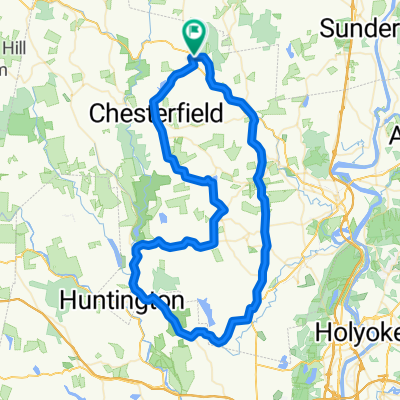
Therese's Work Ride
- 10.7 km
- 264 m
- 264 m
- Chesterfield, Massachusetts, United States
A cycling route starting in Chesterfield, Massachusetts, United States.
Overview
Start at Chesterfield Gorge. Turn right onto Ireland Street and goto the end of Ireland Street to the stop sign at the junction of route 143. Go straight across the intersection onto Cuminon Road. Follow Cummington Road into Cummington (It will become Fairgrounds Road) and follow it past the Cummington Fair, down the hill andto the Stop sign at the junction of Route 9. Turn left onto route 9 west. Follow Route 9 into West Cummington. Turn right onto West Main Street (signs for Windsor Jams). West Cummington Congregational church Parish House will be on your left (food stop). Continue down West Main Street and follow it to the stop sign to the junction of route 9. Turn left onto Route 9, go down the hill and turn right onto West Cummington Road. Follow West Cummington Road to the junction of Route 112. Go straight onto 112, continuing onto West Cummington Road. Follow it into Worthington where it becomes Dingle Road. Turn left onto Capen Street and follow it to the stop sign where it meets route 143. Turn left onto Route 143 and follow it into Chesterfield. Turn right onto Ireland Street (signs for Chesterfield Gorge) and then turn left onto river road and back to the Four Seasons Club.
created this 10 years ago
Route quality
Road
3.9 km
(11 %)
Quiet road
1.8 km
(5 %)
Paved
8.9 km
(25 %)
Unpaved
1.8 km
(5 %)
Asphalt
8.9 km
(25 %)
Unpaved (undefined)
1.8 km
(5 %)
Undefined
24.8 km
(70 %)
Continue with Bikemap
You would like to ride Therese's Weekend Church ride or customize it for your own trip? Here is what you can do with this Bikemap route:
Free trial for 3 days, or one-time payment. More about Bikemap Premium.
Discover more Premium features.
Get Bikemap PremiumFrom our community
Open it in the app