

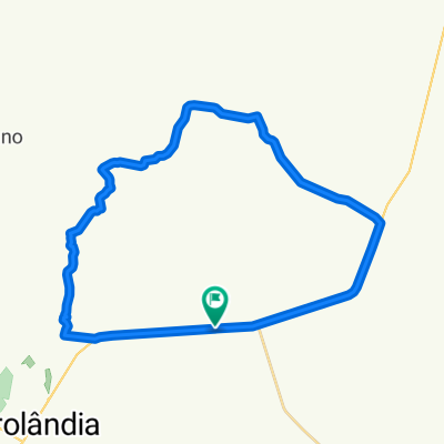
Volta dos Perdidos
A cycling route starting in Sidrolândia, Mato Grosso do Sul, Brazil.
Overview
About this route
Volta dos Perdidos corrigida
56km 821 hm- -:--
- Duration
- 55.7 km
- Distance
- 521 m
- Ascent
- 523 m
- Descent
- ---
- Avg. speed
- ---
- Max. altitude

Route quality
Waytypes & surfaces along the route
Waytypes
Quiet road
21.2 km
(38 %)
Road
16.2 km
(29 %)
Surfaces
Paved
15.9 km
(29 %)
Unpaved
29.4 km
(53 %)
Unpaved (undefined)
29.4 km
(53 %)
Asphalt
13.2 km
(24 %)
Continue with Bikemap
Use, edit, or download this cycling route
You would like to ride Volta dos Perdidos or customize it for your own trip? Here is what you can do with this Bikemap route:
Free features
- Save this route as favorite or in collections
- Copy & plan your own version of this route
- Sync your route with Garmin or Wahoo
Premium features
Free trial for 3 days, or one-time payment. More about Bikemap Premium.
- Navigate this route on iOS & Android
- Export a GPX / KML file of this route
- Create your custom printout (try it for free)
- Download this route for offline navigation
Discover more Premium features.
Get Bikemap PremiumFrom our community
Other popular routes starting in Sidrolândia
 Trilha do Italiano / Toiti
- Distance
- 33.2 km
- Ascent
- 342 m
- Descent
- 342 m
- Location
- Sidrolândia, Mato Grosso do Sul, Brazil
 Trilha Cerro Corá.
- Distance
- 40 km
- Ascent
- 396 m
- Descent
- 396 m
- Location
- Sidrolândia, Mato Grosso do Sul, Brazil
 1º Passeio Ciclístico Mais Saúde e Menos Poluição - Embarrados MS
- Distance
- 6.8 km
- Ascent
- 27 m
- Descent
- 22 m
- Location
- Sidrolândia, Mato Grosso do Sul, Brazil
 115km Capao Seco - Bonito - Sidro
- Distance
- 115.4 km
- Ascent
- 419 m
- Descent
- 425 m
- Location
- Sidrolândia, Mato Grosso do Sul, Brazil
 048 - Cerro Corá - Tombo - 41.60 km (Odo 897.3 km)
- Distance
- 41.6 km
- Ascent
- 382 m
- Descent
- 382 m
- Location
- Sidrolândia, Mato Grosso do Sul, Brazil
 Cerro Corá 2?
- Distance
- 54.1 km
- Ascent
- 488 m
- Descent
- 488 m
- Location
- Sidrolândia, Mato Grosso do Sul, Brazil
 Volta dos Perdidos
- Distance
- 55.7 km
- Ascent
- 521 m
- Descent
- 523 m
- Location
- Sidrolândia, Mato Grosso do Sul, Brazil
 Trilha light Coronel Cesar.
- Distance
- 22.3 km
- Ascent
- 53 m
- Descent
- 52 m
- Location
- Sidrolândia, Mato Grosso do Sul, Brazil
Open it in the app