

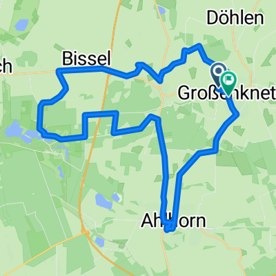
Dötlingen-Runde
A cycling route starting in Großenkneten, Lower Saxony, Germany.
Overview
About this route
Hagel (Schafstall) - Engelmannsbäke - Aumühle - Spasche - Autobahnbrücke über Hunte - Hunteradweg nach Dötlingen - Klänerhof - Huntepadd - Ölmühle - Moorbek - Heinefelde - Hagel (Schafstall)
- -:--
- Duration
- 42.5 km
- Distance
- 103 m
- Ascent
- 102 m
- Descent
- ---
- Avg. speed
- ---
- Avg. speed
Route quality
Waytypes & surfaces along the route
Waytypes
Quiet road
19.5 km
(46 %)
Track
8.8 km
(21 %)
Surfaces
Paved
26.8 km
(63 %)
Unpaved
15.4 km
(36 %)
Asphalt
18.5 km
(43 %)
Gravel
8.3 km
(19 %)
Continue with Bikemap
Use, edit, or download this cycling route
You would like to ride Dötlingen-Runde or customize it for your own trip? Here is what you can do with this Bikemap route:
Free features
- Save this route as favorite or in collections
- Copy & plan your own version of this route
- Sync your route with Garmin or Wahoo
Premium features
Free trial for 3 days, or one-time payment. More about Bikemap Premium.
- Navigate this route on iOS & Android
- Export a GPX / KML file of this route
- Create your custom printout (try it for free)
- Download this route for offline navigation
Discover more Premium features.
Get Bikemap PremiumFrom our community
Other popular routes starting in Großenkneten
 Rundreise
- Distance
- 39.8 km
- Ascent
- 92 m
- Descent
- 93 m
- Location
- Großenkneten, Lower Saxony, Germany
 10 Gemeinde Großenkneten Urwald
- Distance
- 12.7 km
- Ascent
- 35 m
- Descent
- 35 m
- Location
- Großenkneten, Lower Saxony, Germany
 Bahnhofstraße, Großenkneten nach Markt, Oldenburg
- Distance
- 22.3 km
- Ascent
- 23 m
- Descent
- 33 m
- Location
- Großenkneten, Lower Saxony, Germany
 3 Gemeinde Großenkneten Fahrradtour
- Distance
- 23.3 km
- Ascent
- 41 m
- Descent
- 39 m
- Location
- Großenkneten, Lower Saxony, Germany
 2008/09_Durch die "wilde" Geest
- Distance
- 81.2 km
- Ascent
- 74 m
- Descent
- 108 m
- Location
- Großenkneten, Lower Saxony, Germany
 MTB Hunte
- Distance
- 36.8 km
- Ascent
- 47 m
- Descent
- 49 m
- Location
- Großenkneten, Lower Saxony, Germany
 MTB Hunte Runde
- Distance
- 33.8 km
- Ascent
- 68 m
- Descent
- 68 m
- Location
- Großenkneten, Lower Saxony, Germany
 Hauptstraße, Großenkneten nach Bahnhofstraße, Großenkneten
- Distance
- 6.1 km
- Ascent
- 8 m
- Descent
- 26 m
- Location
- Großenkneten, Lower Saxony, Germany
Open it in the app