Trainingsrunde für Anja und Fabian
A cycling route starting in Aach, Baden-Wurttemberg, Germany.
Overview
About this route
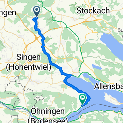
Starting from our home on paved roads to the Anselfingen - Hevensteig hiking parking lot. We climb the Hohenheven via the trail — it is mostly rideable — enjoy the view, and head towards Welschingen (with some sections to walk) for the first stop. After refreshing, we continue on the Ludwig-Finckh-Weg to Weitertingen. There awaits a short climb towards Hohenstoffel. On dirt roads, we reach just before Twiefeld with a view of the imposing Hohentwiel. The next stop is the Hegau nature friends' house. We continue north towards the Hohen Krähen. The ruins invite exploration. After a short descent, shortly before Schlatt unter Krähen, we turn right towards Hausen an der Aach and reach the Radolfzeller Aach stream. With a bit of luck, we can spot beavers. From now on, we ride alongside the Aach upstream to Beuren an der Aach. Now we follow the bike path back to the starting point.
- -:--
- Duration
- 48.8 km
- Distance
- 828 m
- Ascent
- 828 m
- Descent
- ---
- Avg. speed
- ---
- Max. altitude
Route quality
Waytypes & surfaces along the route
Waytypes
Track
17.6 km
(36 %)
Road
8.8 km
(18 %)
Surfaces
Paved
24.9 km
(51 %)
Unpaved
16.1 km
(33 %)
Asphalt
22.4 km
(46 %)
Gravel
9.8 km
(20 %)
Route highlights
Points of interest along the route

Photo after 0.1 km

Point of interest after 13.1 km
Hohenhewen
Point of interest after 16 km
Gasthof Bären
Point of interest after 33.3 km
Naturfreundehaus Hegau-Hotel
Continue with Bikemap
Use, edit, or download this cycling route
You would like to ride Trainingsrunde für Anja und Fabian or customize it for your own trip? Here is what you can do with this Bikemap route:
Free features
- Save this route as favorite or in collections
- Copy & plan your own version of this route
- Sync your route with Garmin or Wahoo
Premium features
Free trial for 3 days, or one-time payment. More about Bikemap Premium.
- Navigate this route on iOS & Android
- Export a GPX / KML file of this route
- Create your custom printout (try it for free)
- Download this route for offline navigation
Discover more Premium features.
Get Bikemap PremiumFrom our community
Other popular routes starting in Aach
 Arbeitsweg
- Distance
- 55.1 km
- Ascent
- 273 m
- Descent
- 310 m
- Location
- Aach, Baden-Wurttemberg, Germany
 Ach - Gaienhofen
- Distance
- 29.2 km
- Ascent
- 133 m
- Descent
- 186 m
- Location
- Aach, Baden-Wurttemberg, Germany
 Rennrad Runde
- Distance
- 38.4 km
- Ascent
- 479 m
- Descent
- 479 m
- Location
- Aach, Baden-Wurttemberg, Germany
 1/2- Tagestour an den Bodensee
- Distance
- 87.6 km
- Ascent
- 279 m
- Descent
- 280 m
- Location
- Aach, Baden-Wurttemberg, Germany
 Aachtopf-Radolfzell-Aachtopf
- Distance
- 49 km
- Ascent
- 171 m
- Descent
- 171 m
- Location
- Aach, Baden-Wurttemberg, Germany
 Laufrunde mittel
- Distance
- 5.9 km
- Ascent
- 66 m
- Descent
- 69 m
- Location
- Aach, Baden-Wurttemberg, Germany
 Kleine Rundfahrt
- Distance
- 111.9 km
- Ascent
- 1,110 m
- Descent
- 1,112 m
- Location
- Aach, Baden-Wurttemberg, Germany
 Rennrad Runde
- Distance
- 38.4 km
- Ascent
- 479 m
- Descent
- 479 m
- Location
- Aach, Baden-Wurttemberg, Germany
Open it in the app


