

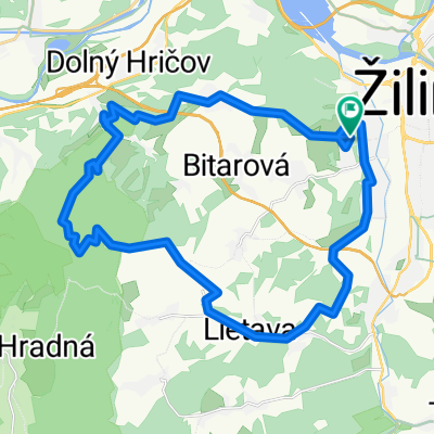
Budatin - Vadicov - Zastranie - Zilina Dam
A cycling route starting in Žilina, Žilina Region, Slovakia.
Overview
About this route
Stredne narocna trasa. Z velkej casti po asfalte, ale su aj narocnejsie terenne useky. Od kaplnky nad Vadicovom (Kotrcinou Luckou) treba ist po cervenej turistickej znacke (chvilu treba bicykel tlacit (alebo riadne zabrat :-)
- -:--
- Duration
- 32.1 km
- Distance
- 581 m
- Ascent
- 567 m
- Descent
- ---
- Avg. speed
- 666 m
- Max. altitude
Route quality
Waytypes & surfaces along the route
Waytypes
Road
17.6 km
(55 %)
Track
7.2 km
(23 %)
Surfaces
Paved
11.8 km
(37 %)
Unpaved
6.4 km
(20 %)
Asphalt
11.5 km
(36 %)
Gravel
3.6 km
(11 %)
Route highlights
Points of interest along the route
Point of interest after 18.5 km
kaplnka (Kotrcina Lucka - stran) pokracovat po cervenej turistickej znacke
Point of interest after 22.3 km
Druzstvo tu opustit cervenu turisticku znacku
Point of interest after 23.4 km
futbalove ihrisko
Continue with Bikemap
Use, edit, or download this cycling route
You would like to ride Budatin - Vadicov - Zastranie - Zilina Dam or customize it for your own trip? Here is what you can do with this Bikemap route:
Free features
- Save this route as favorite or in collections
- Copy & plan your own version of this route
- Sync your route with Garmin or Wahoo
Premium features
Free trial for 3 days, or one-time payment. More about Bikemap Premium.
- Navigate this route on iOS & Android
- Export a GPX / KML file of this route
- Create your custom printout (try it for free)
- Download this route for offline navigation
Discover more Premium features.
Get Bikemap PremiumFrom our community
Other popular routes starting in Žilina
 Nedeľný výjazd 11.6.2017
- Distance
- 32.1 km
- Ascent
- 716 m
- Descent
- 716 m
- Location
- Žilina, Žilina Region, Slovakia
 Z Turia do Višňového
- Distance
- 19.6 km
- Ascent
- 616 m
- Descent
- 616 m
- Location
- Žilina, Žilina Region, Slovakia
 Rajeckou dolinou cez Kunerad do Rajeckých teplíc (stredná) mediamatika
- Distance
- 29.4 km
- Ascent
- 293 m
- Descent
- 218 m
- Location
- Žilina, Žilina Region, Slovakia
 Nezbudska lucka, Krasnany
- Distance
- 33 km
- Ascent
- 317 m
- Descent
- 321 m
- Location
- Žilina, Žilina Region, Slovakia
 Kaštiele (ľahká) mediamatika
- Distance
- 18.4 km
- Ascent
- 95 m
- Descent
- 121 m
- Location
- Žilina, Žilina Region, Slovakia
 Borik,Hajik,Horky,Lietava,Banova,Borik
- Distance
- 20.6 km
- Ascent
- 263 m
- Descent
- 261 m
- Location
- Žilina, Žilina Region, Slovakia
 Žilina (v.d.)- Nezbudská Lúčka (okolo v.nádrže)
- Distance
- 20.5 km
- Ascent
- 96 m
- Descent
- 102 m
- Location
- Žilina, Žilina Region, Slovakia
 Hrady v okolí Žiliny (ľahká) mediamatika
- Distance
- 28 km
- Ascent
- 189 m
- Descent
- 195 m
- Location
- Žilina, Žilina Region, Slovakia
Open it in the app