
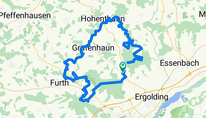
Landshuter Waldtour
A cycling route starting in Ergolding, Bavaria, Germany.
Overview
About this route
Around Käufelkofen, according to bryton rider 50 approximately 900Hm
- -:--
- Duration
- 52.8 km
- Distance
- 629 m
- Ascent
- 629 m
- Descent
- ---
- Avg. speed
- ---
- Max. altitude
Route quality
Waytypes & surfaces along the route
Waytypes
Track
36.5 km
(69 %)
Quiet road
5.8 km
(11 %)
Surfaces
Paved
11.6 km
(22 %)
Unpaved
36.5 km
(69 %)
Gravel
13.7 km
(26 %)
Unpaved (undefined)
11.6 km
(22 %)
Continue with Bikemap
Use, edit, or download this cycling route
You would like to ride Landshuter Waldtour or customize it for your own trip? Here is what you can do with this Bikemap route:
Free features
- Save this route as favorite or in collections
- Copy & plan your own version of this route
- Sync your route with Garmin or Wahoo
Premium features
Free trial for 3 days, or one-time payment. More about Bikemap Premium.
- Navigate this route on iOS & Android
- Export a GPX / KML file of this route
- Create your custom printout (try it for free)
- Download this route for offline navigation
Discover more Premium features.
Get Bikemap PremiumFrom our community
Other popular routes starting in Ergolding
 Isarrunde Ergolding - Volkmansdorf
- Distance
- 42.7 km
- Ascent
- 83 m
- Descent
- 75 m
- Location
- Ergolding, Bavaria, Germany
 Ergolding-Rottenburg an der Laaber
- Distance
- 60.8 km
- Ascent
- 514 m
- Descent
- 516 m
- Location
- Ergolding, Bavaria, Germany
 LA-Mirskofen-Oberglaim-LA
- Distance
- 28.9 km
- Ascent
- 201 m
- Descent
- 201 m
- Location
- Ergolding, Bavaria, Germany
 Landshuter Waldtour
- Distance
- 52.8 km
- Ascent
- 629 m
- Descent
- 629 m
- Location
- Ergolding, Bavaria, Germany
 Aufnahme vom 27. Juli, 20:50
- Distance
- 23.9 km
- Ascent
- 27 m
- Descent
- 25 m
- Location
- Ergolding, Bavaria, Germany
 La-Mirskofen-Weihenstephan-La
- Distance
- 28.9 km
- Ascent
- 192 m
- Descent
- 192 m
- Location
- Ergolding, Bavaria, Germany
 Landshut Hohenthann Runde
- Distance
- 41.7 km
- Ascent
- 182 m
- Descent
- 181 m
- Location
- Ergolding, Bavaria, Germany
 Feierabendrunde
- Distance
- 24.8 km
- Ascent
- 165 m
- Descent
- 168 m
- Location
- Ergolding, Bavaria, Germany
Open it in the app