

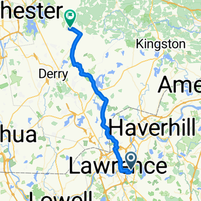
N Andover > Gloucester, Rockport
A cycling route starting in North Andover, Massachusetts, United States.
Overview
About this route
This route is ~45 miles, and add another 28 miles or so if you ride back by retracing Rt 133, etc., from the end point to the start point. For a 70+ mile ride, you may want to have some friends along and so this route starts at Drummond Park on Milk Street which is a convenient place to meet.
The stretch of Rt 133 between Ipswich, through Essex, and into Gloucester is a nice road for bikers. The surface is in good condition and it's wide enough that motor vehicle traffic isn't an issue.
Rt 127A and RT 127 in Rockport is scenic, but the road is thin in places and people sometimes drive too fast. Use caution.
- -:--
- Duration
- 71.3 km
- Distance
- 421 m
- Ascent
- 479 m
- Descent
- ---
- Avg. speed
- 72 m
- Max. altitude
Route quality
Waytypes & surfaces along the route
Waytypes
Road
9.3 km
(13 %)
Quiet road
5 km
(7 %)
Surfaces
Paved
42.1 km
(59 %)
Asphalt
42.1 km
(59 %)
Undefined
29.2 km
(41 %)
Route highlights
Points of interest along the route
Point of interest after 51.2 km
Good Harbor Beach
Continue with Bikemap
Use, edit, or download this cycling route
You would like to ride N Andover > Gloucester, Rockport or customize it for your own trip? Here is what you can do with this Bikemap route:
Free features
- Save this route as favorite or in collections
- Copy & plan your own version of this route
- Sync your route with Garmin or Wahoo
Premium features
Free trial for 3 days, or one-time payment. More about Bikemap Premium.
- Navigate this route on iOS & Android
- Export a GPX / KML file of this route
- Create your custom printout (try it for free)
- Download this route for offline navigation
Discover more Premium features.
Get Bikemap PremiumFrom our community
Other popular routes starting in North Andover
 179 Osgood St, North Andover to 70 Main St, North Andover
- Distance
- 2.1 km
- Ascent
- 51 m
- Descent
- 90 m
- Location
- North Andover, Massachusetts, United States
 Walmart NH and Back
- Distance
- 34.2 km
- Ascent
- 176 m
- Descent
- 177 m
- Location
- North Andover, Massachusetts, United States
 179 Osgood St, North Andover to 315 Turnpike St, North Andover
- Distance
- 3.1 km
- Ascent
- 50 m
- Descent
- 38 m
- Location
- North Andover, Massachusetts, United States
 Gibson Court 30, North Andover to Main Street 2, Andover
- Distance
- 11.5 km
- Ascent
- 27 m
- Descent
- 22 m
- Location
- North Andover, Massachusetts, United States
 Plum Island
- Distance
- 68.1 km
- Ascent
- 185 m
- Descent
- 187 m
- Location
- North Andover, Massachusetts, United States
 By the Sea
- Distance
- 51.6 km
- Ascent
- 151 m
- Descent
- 158 m
- Location
- North Andover, Massachusetts, United States
 Lake Cochichewick Circle
- Distance
- 11 km
- Ascent
- 113 m
- Descent
- 111 m
- Location
- North Andover, Massachusetts, United States
 Trip to work
- Distance
- 41.7 km
- Ascent
- 618 m
- Descent
- 498 m
- Location
- North Andover, Massachusetts, United States
Open it in the app