

Club Vélo Sélect 2009
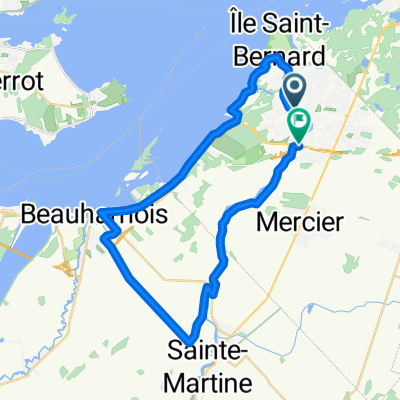
A cycling route starting in Châteauguay, Quebec, Canada.
Overview
About this route
Montérégie Sector
Start from Châteauguay towards St-Barbe, Elgin, Hinchinbrooke, Franklin, Havelock, St-Chrysostome, Howick, St-Martine and return to Châteauguay
- -:--
- Duration
- 199.2 km
- Distance
- 572 m
- Ascent
- 571 m
- Descent
- ---
- Avg. speed
- 340 m
- Max. altitude
Route quality
Waytypes & surfaces along the route
Waytypes
Road
173.3 km
(87 %)
Quiet road
13.9 km
(7 %)
Surfaces
Paved
81.7 km
(41 %)
Asphalt
61.7 km
(31 %)
Paved (undefined)
19.9 km
(10 %)
Undefined
117.5 km
(59 %)
Route highlights
Points of interest along the route
Point of interest after 32 km
Bataille de Châteauguay pour se ravitailler
Point of interest after 61.6 km
Magasin Général pour se ravitailler
Point of interest after 122.3 km
Ravitaillement possible eau potable sur le bord de la 209 chez un fermier.
Point of interest after 131.3 km
Arrêt pour manger au Verger Cassidy et se ravitailler. Descendre la Stevenson et tourner à gauche sur la 202
Continue with Bikemap
Use, edit, or download this cycling route
You would like to ride Club Vélo Sélect 2009 or customize it for your own trip? Here is what you can do with this Bikemap route:
Free features
- Save this route as favorite or in collections
- Copy & plan your own version of this route
- Split it into stages to create a multi-day tour
- Sync your route with Garmin or Wahoo
Premium features
Free trial for 3 days, or one-time payment. More about Bikemap Premium.
- Navigate this route on iOS & Android
- Export a GPX / KML file of this route
- Create your custom printout (try it for free)
- Download this route for offline navigation
Discover more Premium features.
Get Bikemap PremiumFrom our community
Other popular routes starting in Châteauguay
 Boulevard D'Youville 5, Châteauguay to Rue des Sittelles 200, Châteauguay
- Distance
- 38.7 km
- Ascent
- 170 m
- Descent
- 172 m
- Location
- Châteauguay, Quebec, Canada
 Chateauguay 55 km
- Distance
- 54.9 km
- Ascent
- 29 m
- Descent
- 24 m
- Location
- Châteauguay, Quebec, Canada
 Chautauguay(Circuit de la rivière Châtauguay)
- Distance
- 56.3 km
- Ascent
- 79 m
- Descent
- 76 m
- Location
- Châteauguay, Quebec, Canada
 ced route 2
- Distance
- 39.9 km
- Ascent
- 51 m
- Descent
- 51 m
- Location
- Châteauguay, Quebec, Canada
 Itinéraire vers 500 Boul d'Youville, Châteauguay
- Distance
- 41.7 km
- Ascent
- 83 m
- Descent
- 88 m
- Location
- Châteauguay, Quebec, Canada
 132 Rue Henriette-Caron, Châteauguay to 169 Rue Principale, Saint-Louis-de-Gonzague
- Distance
- 31.1 km
- Ascent
- 10 m
- Descent
- 0 m
- Location
- Châteauguay, Quebec, Canada
 Chateaugay-St-Louis de Gonzague-Beauharnois
- Distance
- 75.7 km
- Ascent
- 51 m
- Descent
- 51 m
- Location
- Châteauguay, Quebec, Canada
 Club Vélo Sélect 2009
- Distance
- 199.2 km
- Ascent
- 572 m
- Descent
- 571 m
- Location
- Châteauguay, Quebec, Canada
Open it in the app