
PMC 2008 Day 2
A cycling route starting in Buzzards Bay, Massachusetts, United States.
Overview
About this route
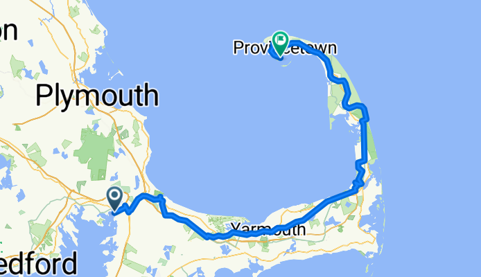
Pan-Mass Challenge (PMC), Day 2, Bourne to Provincetown.
- -:--
- Duration
- 125.3 km
- Distance
- 503 m
- Ascent
- 496 m
- Descent
- ---
- Avg. speed
- 78 m
- Max. altitude
Route quality
Waytypes & surfaces along the route
Waytypes
Road
33.8 km
(27 %)
Cycleway
25.1 km
(20 %)
Surfaces
Paved
80.2 km
(64 %)
Unpaved
1.3 km
(1 %)
Asphalt
77.7 km
(62 %)
Paved (undefined)
1.3 km
(1 %)
Route highlights
Points of interest along the route
Point of interest after 38.9 km
Waterstop #1, Barnstable County Complex
Point of interest after 66.1 km
Waterstop #2, Nickerson State Park
Point of interest after 66.3 km
Start of Cape Cod Rail Trail segment. Route is approximate.
Point of interest after 69 km
End of Cape Cod Rail Trail segment. Route is approximate.
Point of interest after 79.2 km
Start of Cape Cod Rail Trail segment. Route is approximate.
Point of interest after 86.3 km
End of Cape Cod Rail Trail segment. Route is approximate.
Point of interest after 93.5 km
Waterstop #3, Wellfleet Elementary School
Continue with Bikemap
Use, edit, or download this cycling route
You would like to ride PMC 2008 Day 2 or customize it for your own trip? Here is what you can do with this Bikemap route:
Free features
- Save this route as favorite or in collections
- Copy & plan your own version of this route
- Split it into stages to create a multi-day tour
- Sync your route with Garmin or Wahoo
Premium features
Free trial for 3 days, or one-time payment. More about Bikemap Premium.
- Navigate this route on iOS & Android
- Export a GPX / KML file of this route
- Create your custom printout (try it for free)
- Download this route for offline navigation
Discover more Premium features.
Get Bikemap PremiumFrom our community
Other popular routes starting in Buzzards Bay
 PMC 2008 Day 2
- Distance
- 125.3 km
- Ascent
- 503 m
- Descent
- 496 m
- Location
- Buzzards Bay, Massachusetts, United States
 Recovered Route
- Distance
- 20.9 km
- Ascent
- 166 m
- Descent
- 136 m
- Location
- Buzzards Bay, Massachusetts, United States
 Bourne to Provincetown (Inn)
- Distance
- 124.1 km
- Ascent
- 646 m
- Descent
- 645 m
- Location
- Buzzards Bay, Massachusetts, United States
 Cape Cod Canal Bikeway
- Distance
- 11.4 km
- Ascent
- 41 m
- Descent
- 40 m
- Location
- Buzzards Bay, Massachusetts, United States
 cape canal bikeway -- first leg
- Distance
- 12.1 km
- Ascent
- 13 m
- Descent
- 17 m
- Location
- Buzzards Bay, Massachusetts, United States
 Sandwich to Provincetown
- Distance
- 151.6 km
- Ascent
- 267 m
- Descent
- 255 m
- Location
- Buzzards Bay, Massachusetts, United States
 Steady ride in Buzzards Bay
- Distance
- 22.8 km
- Ascent
- 55 m
- Descent
- 120 m
- Location
- Buzzards Bay, Massachusetts, United States
 Cape Cod Canal - Point to Point
- Distance
- 25.6 km
- Ascent
- 47 m
- Descent
- 46 m
- Location
- Buzzards Bay, Massachusetts, United States
Open it in the app